Greenville Falls State Scenic River Area
9140 Covington-Gettysburg Rd., Covington MAP IT
The Greenville Falls Natural Arch is one of only a few limestone arches in Ohio and best viewed from a kayak in Greenville Creek, although it can be seen while hiking at the park.
The arch (made of 400 million year old Silurian limestone bedrock) formed through a combination of erosion and weathering processes that gradually shaped the limestone. The arch most likely developed as water found weak points or fractures in the limestone along the edge of Greenville Creek, slowly eroding these spots.
A similar rock arch is located nearby on private property, making western Miami County (geologically speaking) a very unique place!
Greenville Falls Natural Arch is located on the north side of Greenville Creek, just east of the waterfall. It is best viewed in the winter and early spring. Otherwise, it tends to blend in with the rocky gorge. It is open sunrise to sunset daily.


Fort Hill State Memorial
13614 Fort Hill Rd., Hillsboro MAP IT
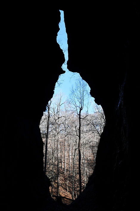
Fort Hill State Memorial, and more particularly the gorge of Baker Fork, contains the largest concentration of natural arches at one site in the state—a total of seven, including the famous The Keyhole, the Natural Y Arch and the Spring Creek Arch, among others.
Fort Hill is arguably one of the best hiking destinations in Ohio, not to mention one of the most vibrant places to see spring wildflowers in bloom. It contains old growth forests, meandering streams, ancient earthworks and quiet and solitude.
Although all of the hiking trails are worth trekking, to see the arches, hike the Gorge Trail and the Canby’s Mountain Lover Trail, both of which span about 3 miles each and are accessible from the State Memorial parking lot.
The Keyhole (probably the most popular feature in the park) is located on the Canby’s Mountain Lover Trail. In fact, the trail passes directly through the keyhole! (Note: If you approach the Keyhole from the Gorge Trail, you will be required to cross a shallow stream to reach it). Other arches are scattered along the Baker Fork Creek and its tributaries.
Both of these trails, which can be described as moderately difficult, also connect to the Fort Trail, which takes hikers 500 feet above the valley to the site of a 2,000 year old Hopewell Native American earthwork that was used as a place of ceremony or for astronomy, or both. The trails also connect to the Buckeye Trail.