


Story & Photos by Matt Bayman


In the 1830s and 1840s, railroads were being built at an unprecedented rate in the United States, for both industry and travel. By 1850 (roughly 20 years after its invention) more than 9,000 miles of rail lines crisscrossed the nation, with thousands more planned or in the works.
A considerable amount of the iron used to make these early railroads (and other products of the Industrial Revolution) came from a region known as The Hanging Rock Iron Region—an area that includes parts of northeastern Kentucky and southern Ohio. In Ohio, it spans from the Ohio River in Lawrence County all the way north into the Hocking River Valley. As its name indicates, the region was known for its massive deposits of iron ore (and coal)—deposits that were considered easy and profitable to extract.
In the name of progress (and later to help win the Civil War), but to the detriment of the environment, the first iron smelting furnace in Ohio opened in 1826, followed by nearly 100 more in the region, mostly in the Buckeye State. With little concern for the land or its future, huge swaths of The Hanging Rock Iron Region were not only cleared of iron ore and coal, but also native trees, plants and wildlife. In order to generate enough heat to run the furnaces, old growth forests were cleared and burned, and later coal was used. Through unregulated mining practices, the region’s topsoil was cleared, its groundwater was contaminated and an ecosystem that had thrived for eons was nearly decimated.

Pictured here in a photo from Ohio History Connection is the Hecla Furnace near Ironton, Ohio. It was in operation from 1833 to the 1890s, producing pig iron used for tools, weapons (during the Civil War), construction and railroads. It was named after Mount Hekla, a volcano in Iceland, symbolizing its fiery operation. In order to operate, the furnace required enormous amounts of timber. One furnace (among the dozens in southern Ohio) could consume an acre of hardwood forest every day. The impact of this devastation lingers in southern Ohio to this day, especially along Ohio Route 93.

By the turn of the 20th century, the region had been depleted of its resources and left in the dust. The boom towns that grew around and supported the iron industry, including Ironton, Jackson and New Straitsville (among numerous others) took major hits, with many residents moving to Pittsburgh and West Virginia, where new methods in steel production and easy access to coal attracted a new generation of industrialists—who then repeated the same kind of pillage as in Ohio until the whole region was said to have “rusted.”
When you drive the entire length of Ohio Route 93, which passes through the heart of The Hanging Rock Iron Region, the ghosts of this belligerent past still haunt the landscape, from orange-colored streams and out-of-place swamps (i.e. strip mines) to slag-covered streams and the remnants of the historic iron furnaces themselves.
A furnace stack is a giant pyramid-shaped object made with large stone blocks. They were used to smelt iron and were often built in the sides of hills near creeks. When you stumble upon a furnace stack in the middle of the woods today, (which happens to be a worthwhile adventure) they look like something out of an Indiana Jones film. Some of the stacks (which were as tall as 80 feet) are so overgrown with vines, underbrush and trees that, unless it’s winter or early spring, you can’t even see them, even if you’re standing only a few feet away! Others are preserved in parks and other designated areas.


The best-preserved furnace in Ohio is Buckeye Furnace State Memorial (pictured above). It’s located not far from Route 93 in rural Jackson County and is unique because, compared to all other furnace sites in the state, it contains the wooden structures that once surrounded and housed each furnace stack, as well as some of the gadgets and machinery that were used to operate them. This, along with historic photographs and exhibits, helps tourists understand the size and scope of these massive operations and their impact on the environment.
At Buckeye Furnace, and other historical landmarks along Route 93, travelers can also learn about the people who worked in the early iron and coal industries in Ohio, often in terrible, dangerous conditions and for poor wages, including child workers.
One of the most interesting stories (and historical attractions on Route 93) is that of Robinson’s Cave, which also happens to be a birthplace of the labor movement in the United States.
Robinson’s Cave, now a public park and historic site, is a natural rock formation situated in the hills above New Straitsville. It provided a secluded and safe meeting place for miners who were organizing to improve their working conditions during the late 19th century. It was named after J.M. Robinson, a local (apparently sympathetic) mine owner who allowed the miners to use his cave to meet.
In September of 1876, miners from various parts of Ohio convened in Robinson’s Cave to form the Ohio Miners’ Amalgamated Association (OMAA). This organization aimed to unite miners to collectively bargain for better wages, improved working conditions and safer environments. It was one of the first such movements of its kind. The OMAA would eventually become the United Mine Workers of America, a powerful organization that exists to this day.


Just up the road from Robinson’s Cave on Route 93 is a similar, yet not-so-glorious historic site, one that commemorates the New Straitsville Mine Fire, also known as the “World’s Greatest Mining Fire.”
A historical marker at the entrance of what is now called the Upstream Rock Run Reclamation Site (where the fire occurred, and that is now a nature preserve open to the public) explains that, in 1884, during a bitter strike by miners against the New Straitsville Mining Company (who had just lowered worker wages and brought in strike breakers), at least six striking miners set fire to coal cars at various locations and pushed them inside of the mine. While this was an attempt to slow down operations at the mine, the stunt backfired and the fires quickly spread and ignited an underground coal seam that, sadly, 140 years later, is still burning!
According to the U.S. Forest Service (which manages the affected area in Wayne National Forest), in the early years of the fire, the massive coal seam burned and turned into ash, causing the ground to collapse under building foundations and roads. This, along with mine gases that were seeping into schools and homes in the area, caused many residents to move away. However, in their place came a trove of tourists, as word soon spread that, in New Straitsville, roses bloomed in the winter and potatoes could be baked in the ground.
Years later, in the 1930s, Ripley’s Believe It or Not broadcast a radio report on the fire and held a microphone into the crackling flames in the ground for all to hear. According to the U.S. Forest Service, after the broadcast, interest in the story was so great that many local landowners started tourism companies that marketed what they called “The World’s Greatest Mine Fire.” In the years that followed, New Straitsville became a renowned tourist destination and was the subject of international news. Thousands of people flocked to the area and paid 25 cents to see eggs being cooked over a hot, smoking hole in the ground, hot water being drawn out of residents’ wells, and the remains of roads and houses that had sunk into the ground.
To this day, snow melts on the ground above where the fire burns and holes occasionally open up and spew steam and smoke, sometimes quite high in the air. According to Ohio History Connection, smoke has been seen emerging from the ground as recently as 2003.
A walk around the Reclamation Site in New Straitsville today demonstrates how the area is now returning to its natural state and attracting wildlife.
In fact, thanks to public, private and volunteer efforts, The Hanging Rock Iron Region (and the communities within it) is beginning to heal from its past, with re-grown forests and old mining areas now serving as parks, nature preserves and recreational areas for the public to enjoy (and animals to live in), including many that are located along Route 93.


However, driving the entire length of Route 93 highlights much more than just The Hanging Rock Iron Region.
Spanning 234 miles from Ironton to Akron, Route 93 also passes through Ohio’s beautiful Amish Country, plus the Hocking Hills region and many charming small and medium-sized towns, including Logan, Zanesville and Canal Fulton, each that offers its own unique attractions, shops, restaurants and lodging options. It’s a beautiful drive, made even more beautiful in the fall, when the leaves change color and many of the towns along Route 93 host festivals, farm markets, haunted houses, corn mazes and other fun activities. Most of all, driving the entire length of Route 93 is a chance to explore 234 miles of some of Ohio’s most unique and often forgotten places (and history)—places that, because of their remote locations, few people ever see!


Let’s Get Started, But First…
The following trip is meant to be driven from south to north, starting in Ironton on the Ohio River and traveling to the outskirts of Akron, where the road ends. While most attractions mentioned here can be found directly on Route 93, others require a short detour (and sometimes a short hike) from the route—which brings us to our final points and words of warning!
The Hanging Rock Iron Region, and many other forested areas near Route 93, is not fully developed. It’s mostly national and state forest land. Although Route 93 is always well-maintained, many forest roads that lead off of it (and to interesting places) are made of dirt and gravel, and some have a lot of potholes! So be forewarned.
Likewise, although visible and easily navigable, many hiking trails in the forests next to Route 93 (such as when visiting old furnace sites and caves) are fairly overgrown. Wearing long pants and long-sleeve shirts is always a good idea, as is bringing bug spray (especially in the summer), sturdy shoes and a hat.
There are a few steep climbs on the hiking trails on this trip (Tinker’s Cave being one of them), not to mention several off-the-beaten path locations that can be hard to find, even with a cell phone map. While phone reception is available in most locations, it can disappear on some of the back roads, so it’s probably a good idea to bring a regular map for backup.
Finally, while traffic is fairly light on Route 93 (and sometimes non-existent on side roads), you will occasionally share the road with logging trucks that use not only Route 93, but some of the back roads in the area. You can usually hear them coming from pretty far away and you’ll want to give them plenty of room.
With that said, let’s get started! The following is just some of what you can see when driving the entire length of Ohio Route 93.
Enjoy and drive safely!

Ohio Route 93 starts at the Ohio River, right in front of The Depot restaurant in downtown Ironton. It then passes the Lawrence County Courthouse before leaving town. At the intersection of S. 4th St. and Park Ave. (on the courthouse lawn), look for a furnace-shaped monument and an Ohio Historical Marker (pictured below). On the front of the marker is the story of The Hanging Rock Iron Region. On the back is a list of the furnaces that existed in Lawrence County, several of which will be visited on this trip.


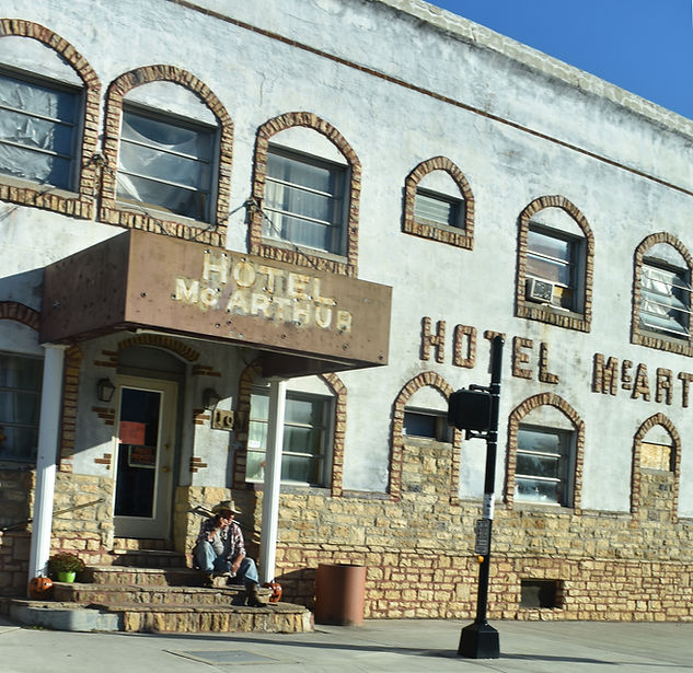
On the edge of Ironton is another relic from the town’s iron heyday—the Route 75 Tunnel. The 165-foot tunnel (half-a-football-field long) was built in 1866 to allow horse and buggies (and iron) to move between the hills and the river community of Ironton. When cars were invented, the tunnel was enlarged, but was unable to handle the traffic flow. When Ohio Route 93 was built in 1960, the tunnel was closed, eventually reopening as a tourist attraction and, on Saturdays in October, as a haunted house that raises money for the local Lion’s Club.
On a regular day, visitors can see the exterior of the tunnel (but not go inside) and also climb a long set of wooden stairs to the top of the tunnel hill. At the top, a platform provides panoramic views of downtown Ironton and the Ohio River, (see videos below).


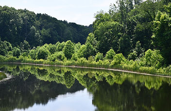
The first attraction in Wayne National Forest on this trip is Lake Vesuvius and its popular Lakeshore Trail. The trail includes a long boardwalk that passes next to the lake and is especially beautiful in the fall. This will also be your first chance to see a furnace stack—Vesuvius Furnace, which happens to be located next to Vesuvius Dam, another interesting attraction at the park.
Beyond the boardwalk trail, the recreation area contains many other hiking trails (if time is short, hike the Rock House Trail and Whiskey Run Trail), as well as modern and primitive camping options. Kayaking and fishing are very popular here.
Look for more interesting relics and sights in and around Pedro, Ohio!


A railroad tunnel that is much less desirable to visit is the nearby Royersville Tunnel. The tunnel (complete with timber supports) was part of the Iron Railroad (later the Detroit, Toledo & Ironton Railway) that began operating in the 1850s to transport iron ore, coal, timber and limestone to the Ohio River. The tunnel (and railroad) was used all the way up to 1979, but was abandoned in 1982 and is now part of Wayne National Forest. During its heyday, the tunnel was 1,050 feet long but was prone to collapse. It is still prone to collapse today and, because of this, is fenced off at both ends and illegal to enter. However, if you just want to see the exterior of the tunnel, it is located on public land and can be visited. But, be warned, people use the area around the tunnel to dump trash, and the orange stream that now floods the old rail line and tunnel (see below) is filled with pollution and trash. It’s not a very flattering place at all!
There is no signage or indication that the tunnel exists, but it can be found on Google Maps. To reach it from Route 93 (just south of the Ironton Ranger Station), take a left on Pine Grove-Smokey Row Rd. and then a quick left on Tunnel Ridge Road. Finally, turn left on La Grange-Boyersville Road. The tunnel is located 500 feet on your right in the woods. You’ll need to park in the grass on the side of the road and look down a steep hill to see the tunnel. It looks like a cave, but look closer and you’ll see that it’s manmade. It’s probably best to visit in the winter or late fall, after the underbrush and bugs have gone away. (See more pics HERE).


If a historic marker and other signage weren’t in place, it would be very easy to miss Olive Furnace when driving along Route 93. At one time, it was possible to walk right up to the furnace stack from the road, but today, due to extreme overgrowth and neglect, it is very hard to reach, especially in the summer and early fall. However, Township Hwy 239 (which is only 600 feet long and located just south of the furnace on Route 93) provides access to the area. A gravel road behind the furnace allows visitors to walk up behind the structure and see its unique stone arch and furnace stack. One of the main things visitors will notice is the amount of slag (a byproduct of iron smelting that looks like black glass) that is still all over the ground in the area, some 130 years later!


After traveling through the forest for more than 30 miles, drivers will reach the quiet town of Oak Hill. During the American Civil War, much of the iron produced at a furnace in Oak Hill (known as Jefferson Furnace) was used to make the famous Union warship the Monitor, as well as the seven-ton guns at Harper’s Ferry. The remains of the furnace can be seen at Jackson Lake State Park, which the town borders. The lake, often surrounded by tall hills, is popular for kayaking and fishing. It is very scenic in the fall.


If you’re not interested in seeing more furnaces, continue north on Route 93, but if you’re up for a little adventure and want to see more, take a short detour to the Cooper-Hollow Wildlife Area (just north of Oak Hill), which is home to the Limestone and Madison furnaces. Both furnace stacks are located in very remote areas and stand out in their own ways—Limestone is very large, while the stones used to build Madison furnace are red in color. Again, slag is all over the place at both sites, as if they were used recently!
Both furnaces are located on CH&D Road and have signage. A short hike across a small field is required to reach Madison, but it is well-maintained.


After long treks in the wilderness, Jackson is a great place to stop for lunch or dinner. The city is home to the famous Arch and Eddie’s restaurant, as well as several other noteworthy places, including The Spot on Main, Sixth Sense Brewing & Taproom, Rowdy’s Smokehouse and Michael’s Ice Cream.
If you have time and are interested in learning more about the history of The Hanging Rock Iron Region (but from a different vantage point), visit the Lillian Jones Museum at 75 Broadway St. Its hours are 10 a.m. to 3 p.m. Tuesday-Thursday. Admission is free.
Several historical markers in Jackson note that, at one time, the town was known as the center of Ohio’s apple growing industry. An apple-shaped water tower is a nod to this past, as is the annual Apple Festival in September.
The community also played a role in the only Civil War “battle” to take place in Ohio, known as Morgan’s Raid. A self-guided driving tour highlights the path of the raid and has several stops in Jackson.
NOTE: In a moment, you’ll pass through Coalton, another town-name that beckons to the past.


As mentioned in the introduction to this article, this state memorial is the only place in Ohio where you can see a reconstructed charcoal-fired iron blast furnace (circa 1852) and its original stack (a large one at that)! The historic site is located away from Route 93 in a very remote area, but it’s worth visiting. A museum at the site is open from noon to 4 p.m. Friday through Sunday, May through October. The address is 123 Buckeye Park Rd., Wellston. The area is very popular for hiking and is especially quiet and peaceful, and very colorful in the fall.


After taking an eastward course, in Wellston Route 93 moves back toward the north. If you made the detour to Buckeye Furnace and want to see another interesting sight on your way back to Route 93, put in map coordinates for 6173 Ohio Route 327, located just south of Wellston. Here, you’ll see an abandoned water park that, if you have the money, is for sale! It’s an unusual sight that, apparently, has a somewhat dark history.
To the north of Wellston, closer to Route 93, is Lake Alma State Park, a small but secluded park that is popular for boating and fishing. A highlight at the park is a pedestrian bridge that crosses to an island in the middle of the lake.
A little further north is Lake Rupert and the Wellston Wildlife Area, both of which were part of The Hanging Rock Iron Region.


McArthur proudly refers to itself as the southern Gateway to the Hocking Hills Region, but it also acts as a gateway to Zaleski State Forest and Lake Hope State Park—home to the famous Moonville Tunnel and several noteworthy backpacking trails featured HERE.
Route 93 skirts along the eastern edge of Hocking Hills State Park. This means many of the park’s most popular destinations, such as Old Man’s Cave and Rock House, require a short detour to reach. However, Route 93 passes directly through an area that contains some of the most interesting bed and breakfasts in the Hocking Hills region. This includes The Gingerbread Haus (located next to Hocking Hills Scenic Air Tours), the famous Ravenwood Castle, and Nature Mystique Retreat (located in the side of a hill and known as a Hobbit house).


Just like McArthur, Logan acts as a gateway to Hocking Hills State Park. It contains a Hocking Hills Visitor Center, a beautiful mural depicting the Upper Falls at Old Man’s Cave (see below right) and is home to Hocking Hills Moonshine, where tours of the distillery can be taken. It’s also a great place to grab a bite to eat, as well as to shop or stay the night. If you have time, don’t miss the Paul A. Johnson Pencil Sharpener Museum, featuring 3,400+ sharpeners! Even better, play paintball or tackle a high ropes course at nearby NevilleBillie Adventure Park.


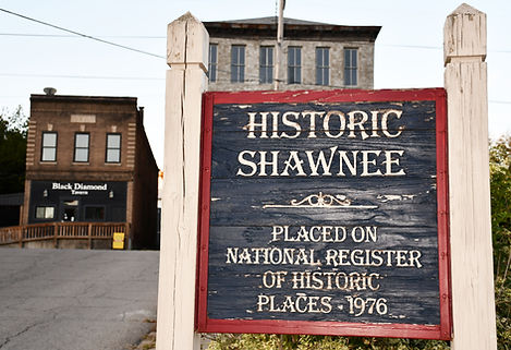
Along with being home to the famous Robinson’s Cave historic site and “World’s Greatest Mine Fire” (both mentioned in the introduction to this article), New Straitsville hosts an annual Moonshine Festival each Memorial Day Weekend. The popular festival is a tribute to when moonshine was produced in the surrounding hills during Prohibition.
The town (and this area of Ohio in general) is very ATV-friendly and there are a number of ATV trails in the region, almost all located on public lands. Most towns also have signs indicating that ATV traffic is welcome. If you don’t have your own, look into renting one from Bigfoot ATV Rentals, located right across the street from Robinson’s Cave.
Finally, before you leave town, visit “The World’s Greatest Fire” mural (seen in the introduction to this article) in downtown New Straitsville.


To this day, Tinker’s Cave (technically a rock shelter) is located in the woods in the middle of nowhere, far from the prying eyes of anyone (but still not too far to reach from Route 93 in New Straitsville). To get there, adventure-seekers must drive a series of gravel and dirt roads in Wayne National Forest, locate an obscure parking lot that has no signage and then descend a very steep hill on a trail that has no name. At the bottom of the hill (the trail is short) is a cave that got its name from a notorious horse thief (with the last name of Tinker) that would keep his stolen horses in this secluded cave. It is said that 20 horses could fit in the deep rock shelter. Folklore in the region has evolved to the point that it is said that the ghosts of Tinker (a man with a colorful and checkered life) and his horses haunt the cave, and can be heard in the still of the night. Hocking Hills ghost tours sometimes visit the area.
The rock shelter probably has a much deeper history that dates back to the late Paleolithic, some 10,000 years ago (and beyond), as well as into modern Native American times.
Not far from Tinker’s Cave is another unmarked landmark—Shawnee Tower. Not long ago, it was a functioning fire tower that the public could climb for panoramic views of the forest. It is now closed and fenced in, and any signage indicating the tower exists is gone, but you can still visit it.
Both Tinker’s Cave and the fire tower are located next to the intersection of Jacobs Road, Burton Hill Road and Sand Run Road. Approaching from the south, the main road (Sand Run) is paved. Coming in from the north (where Route 93 is), the roads are a mix of dirt and gravel, with regular potholes.
To reach the intersection, follow Main Street/Ohio Route 216 east out of New Straitsville and then take the first right on Sandhill Road.
On the way north, also visit the town of Shawnee!


Just before leaving New Straitsville, look for the Upstream Rock Run Reclamation Site, where, as mentioned in the introduction, a 140-year-old mine fire still burns beneath the ground to this day. Thankfully, the Reclamation Site is safe to visit and offers hiking trails and interpretive signage, as well as a historical marker at the entrance that discusses the event. The address is Rock Run Road, New Straitsville, directly off of Route 93.


Before reaching Ohio’s Amish Country, Route 93 passes through several populated areas, namely New Lexington and Zanesville that are separated by large forested areas, including Perry State Forest.
While there’s not much to see in New Lexington, Zanesville has a number of attractions, including its rare Y Bridge, famous ice cream shop (Tom’s) and, maybe best of all, the impressive Zanesville Museum of Art.
Other stops in Zanesville include Dr. Increase Mathews House Museum and Gardens, the National Road/Zane Grey Museum, the Muskingum River Lock and Dam and Mission Oaks Gardens. It’s also a great place to find affordable hotels, and there are plenty of places to eat.
If you get a chance, visit the Muskingum County Courthouse in downtown Zanesville at night. It is often bathed in different-colored lights, including purple lights, pictured below. There are also numerous veteran sculptures and memorials located around the grounds.


While Amish people live south of Zanesville along Route 93, it is not until north of the city that travelers enter Ohio’s official “Amish Country.” The whole area is quite scenic, and there’s a lot less traffic than many other parts of the road.
Just like Hocking Hills, Route 93 skirts along the eastern edge of Amish Country, so a short detour is required to visit more touristy places like Walnut Creek or Berlin. Luckily, Route 93 includes colorful Amish towns such as Sugarcreek, known for having the largest cuckoo clock in the world, Baltic (stop by the Baltic Mill Winery), and Brewster, home to the Brewster Baylor Beach Park and Brewster Cheese Factory. Other Amish-related sites include Pearl Valley Cheese (open for purchases and tours), the Age of Steam Roundhouse & Museum and, if your timing is right, vast pumpkin fields in the fall in West Lafayette.


We are now far away from The Hanging Rock Iron Region and the Ohio River and approaching the urban area of Akron, with Cleveland and Lake Erie not far beyond. However, Route 93 ends to the south of Akron, just after passing through Portage Lakes State Park, and after travelers have visited historic Canal Fulton.
Just like Johnston Farm & Indian Agency in Piqua, it is possible to take a canal boat ride in Canal Fulton. However, unlike Johnston Farm, the canal ride in Canal Fulton moves along the edge of town.
The community has a number of other fun attractions, from a unique toy store and ice cream shop to access to the Ohio and Erie Canal Towpath (open to bikes and hikes) and several fun parks, including Sluggers & Putters Amusement Park and Clays Park Resort, which is one of the largest Jellystone Campgrounds you’ll see. In fact, it’s so big, it has three entrances on Route 93!
Finally, we reach the last major attraction on Route 93—Portage Lakes State Park. The area around the state park is very nice, including many beautiful homes that surround the lakes. A highlight of the state park is an astronomy viewing area and an astronomy themed hiking trail. The eight Portage Lakes in the park encompass 2,034 acres and are used for boating, fishing and swimming.


