


Leo Petroglyphs, Jackson, Ohio
When Europeans arrived in the Great Lakes region in the 1600s, the Indigenous people they encountered spoke an ancient language family known as Algonquian, which continues to be one of the most spoken Indigenous language families in North America today. It is said to be at least 3,000 years old and likely originated in Ontario. It then spread far and wide, spanning from the Atlantic to the Rockies (see map below). The Shawnee and Miami, whose ancestral lands were in western Ohio when Europeans arrived, spoke (and in some cases continue to speak) variations of this language family.
What is lesser known about this vast group of people is that they also utilized a complex system of symbolism (sometimes called proto-writing) through carvings and designs on rocks, trees, bark, baskets, clothing, and other objects. These symbols varied among different Algonquian-speaking groups but often included common motifs such as animal tracks, spirals, handprints, mythical creatures, and geometric patterns. Some were carved into rock faces, known today as petroglyphs, while others were painted onto surfaces, creating pictographs. These visual markings functioned much like a shared language, allowing different bands and tribes to communicate (and relate) across vast distances, including in Ohio, where several petroglyphs have survived to this day and can be visited by the public—offering a rare glimpse into this symbolic (and disappearing) past.
But, as the Ohio History Connection notes on their website: “The petroglyphs we see today are only the tip of the artistic iceberg!”


The Indigenous people who lived in the Great Lake region and Ohio before Europeans arrived not only spoke a common language, but also utilized a complex system of symbols that conveyed everything from directions to hunting grounds to religious meaning. Although much of this symbolism is lost to time, a number of petroglyph sites still exist.
Above: An ChatGPT depiction of an Indigenous person painting a carved petroglyph. At Left: A ChatGPT rendition of an Indigenous person using a waterway marked by petroglyphs.
At top left: A map showing where Algonquian-speaking people live/lived.

One of the most famous examples of this symbolic tradition is the birchbark scrolls of the Ojibwe (an Algonquian-speaking people who lived in the northeast), which used symbols to record medicinal knowledge, migration stories, and spiritual teachings on portable tree bark. Many of the symbols found on the surviving scrolls (some on display at the Smithsonian) are also found on petroglyphs.
Similarly, the Delaware (who eventually lived in Ohio) used wampum belts, woven from shell beads, as both a form of record-keeping and a means of diplomacy, with specific patterns signifying treaties, historical events, or leadership transitions.
In the Ohio Valley and nearby, the Shawnee and their neighbors are believed to have used symbolic carvings on trees (called “dendroglyphs”) to guide travelers and mark sacred spaces.
This symbolic system was not only practical but also deeply intertwined with the natural landscape. Just as today’s road signs are standardized for easy interpretation, many Algonquian symbols followed recognizable patterns that allowed travelers to navigate efficiently. A series of carved notches or animal tracks on a tree, for example, might indicate the presence of a well-traveled hunting path, while a painted handprint could signal a place of spiritual importance. (Note: One such “handprint” is how Ohio’s famous Black Hand Gorge got its name, although the petroglyph was sadly destroyed in 1828 to make room for the canal).
Beyond navigation, these symbols also played a crucial role in diplomacy and territorial boundaries. Certain markings denoted areas belonging to specific clans or tribal groups, helping to prevent disputes or alerting travelers to the customs and expectations of the land they were entering. In some cases, trails were marked with more elaborate carvings or objects such as stacked stones (cairns) or bent trees, which pointed the way toward important resources like fresh water, safe crossings, or seasonal hunting grounds.


These symbols not only conveyed warnings and teachings but also reinforced a shared worldview (i.e. religion) among Algonquian-speaking peoples and their neighbors. This includes the extensive use of Water Panther and Thunderbird symbolism in rock carvings and scrolls, which were (and remain) an important part of Indigenous cosmology.
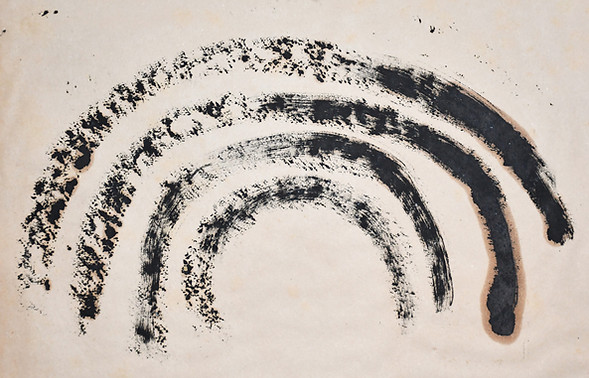
While the Water Panther (also called the Underwater Serpent) was associated with the life-giving and life-taking forces of water and the underworld (and is found carved in abundance near streams, lakes and caves), the Thunderbird was known as the ruler of the sky. Often depicted as a powerful, eagle-like figure, it was said to control storms, bring rain for crops, and strike down chaos with its lightning (Note: Many petroglyphs show a bird with lightning coming out of its beak, sometimes painted with red ochre). Some Indigenous groups believed the Thunderbird carried out divine justice, ensuring that balance and order were maintained.
Carvings of the Thunderbird and Water Panther—found throughout Ohio and the Eastern Woodlands—may have served as signs of protection, marking safe places or locations where ceremonies were performed to honor these powerful forces.
Similar depictions of the Thunderbird have been found as far west as North Dakota (Cheyenne) and Saskatchewan (Cree), as well as throughout eastern North America, indicating the belief system (and Algonquian language system) spanned far and wide. In fact, and intriguingly, the St. Victor Petroglyphs Provincial Historic Park in Saskatchewan, Canada features a bear foot petroglyph that looks very similar to those found at Leo Petroglyphs (near Jackson) in Ohio—a distance of 1,343 miles as the crow flies!
Other similarities abound.
However, as we’ll see, much about the petroglyphs of North America are a great mystery and can only be speculated about, even with help from Indigenous people. With no written record to confirm, there are coincidences, overlaps and misinterpretations that pop up in the data. Or, as the foremost authority on the subject, the late James Swauger, once said of studying the petroglyphs: “Interpretation is a perilous venture.”

The drawings seen here, and throughout this article, were completed in 1908 by an East Liverpool, Ohio resident named Harold Barth. Barth spent a year transferring 200 petroglyph images etched on the banks of the Ohio River near his home (an area known as the “Antique Sculptures” by early explorers) onto paper. When dams were built in the area in the 1920s, the petroglyphs disappeared beneath the water. Prior to 2024, the drawings were housed at the Museum of Ceramics in East Liverpool (which is where the author of this article photographed them).
They have since been moved to a special off-site storage area.
The images seen in this section depict the Thunderbird and Underwater Serpent.


Another symbol frequently found in petroglyphs is the figure of a human with raised arms or who is part human, part animal (therianthrope and/or anthropomorphic), often interpreted as a shaman or spiritual leader. This type of figure may have represented a person in communication with the spirits, guiding their community through vision quests, healing rituals, or ceremonies and is often found on so-called “Teaching Rocks.” In fact the Algonquian word for “petroglyphs” (as we call them) is, in fact, “the rocks that teach.”
Teaching Rocks are stone surfaces etched with sacred knowledge (often featuring dozens of petroglyphs in one small area) that may have been used by shamans in these initiation rites, helping younger generations understand the spiritual and natural forces governing their world, and how to navigate through life. Ohio’s most famous petroglyphs, Leo Petroglyph and Inscription Rock on Kelleys Island (and several others), may have been Teaching Rocks. Interestingly, the largest concentration of petroglyphs in Canada (The Peterborough Petroglyphs in Ontario, not far from Niagara Falls) is referred to as “The Teaching Rocks.” An elaborate display of 300 symbols on the rock surface there, consisting of shamans, animals, reptiles and mythical beings, are said by First Nations people to teach the sacredness of life.
Although their meaning often remains a mystery, what is certain about these petroglyphs and pictographs is that they were still in widespread use when Europeans arrived in the 17th century, and then quickly disappeared from the record as Native Americans were forced from their lands.


(Top left and bottom left) Inscription Rock, Ohio. Three at right, other "Teaching Rocks"(Public Domain)


There are many unanswered questions about the petroglyphs of the Eastern Woodlands, with the most challenging being when they were created.
Dating these ancient carvings is challenging because, unlike objects made of organic material, rocks don’t contain something that can be easily carbon-dated. Instead, archaeologists piece together clues by talking with First Nation people, looking at the style of the artwork, comparing it with other artifacts found in the same area, and examining the layers of soil and other context around the petroglyphs.
With this (and other) information, archaeologists have determined that many of the petroglyphs in the eastern United States (including in Ohio) were carved between 1100 and 1700 AD.
On the other end of the spectrum, however, Peterborough Petroglyphs is estimated to be 9,000 years old, with some dates pushing it past 10,000 years!
The more modern petroglyphs (such as those in Ohio) are believed to have been created by the Fort Ancient people, who the Shawnee are descended from. One of the indications for this is the Fort Ancient fascination with serpents (i.e. Serpent Mound), which are found in numerous petroglyphs and scrolls, as are other related symbols.
Swauger concluded that the petroglyphs found in Ohio (as well as many in Pennsylvania, West Virginia and other parts of the region) were created by “proto-Shawnee” groups roughly around 1100 AD until European contact.
The debate, however, continues.


Benjamin Henfrey’s drawings (from the National Archives) of several petroglyphs found on the Ohio River near what is today Wellsville.

Modern references to petroglyphs date back to the 17th century when French explorers referred to a 10-mile stretch of the Ohio River near modern-day East Liverpool in Ohio as the “Antique Sculptures,” because of the hundreds of carvings seen on the rocky banks of both sides of the river, and more located downstream. Some of these petroglyphs were drawn and sent to Thomas Jefferson in 1798. Years later, as we’ll see in a moment, a local man was able to document the “Antique Sculptures” before the construction of a dam inundated them, possibly forever.
Reports of dendroglyphs (tree markings) were recorded in early European journals in the 17th and 18th centuries, providing us with rare accounts of how some symbols were used in everyday life.
Researched by Fred E. Coy Jr. in his essay, “Native American Dendroglyphs of the Eastern Woodlands,” one such journal reported that Native Americans would peel away bark from the side of a tree until it became white and clean and then draw on that spot. Another reports that “heroes and their triumphs were often carved into the trees” and that the depictions could “last up to 50 years.” Others, he wrote, “showed hunting triumphs, such as the number of bear or deer killed.”
A German missionary in 1779 wrote that in Pennsylvania, “If a party of Indians have spent a night in the woods, it may be easily known, not only by the structure of their sleeping huts but also by their marks on trees, to what tribe they belong. For they always leave a mark behind made either with red pigment or charcoal. Such marks are understood by the Indians who know how to read their meaning.”
Another early settler reported that, sometimes, tree bark was stripped up to 30 feet tall and would be covered in symbols and drawings of animals and birds, almost always in the same two colors—red and black.
Coy speculates that dendroglyphs might be the reason we have so many streams in the Ohio Valley named Paint Creek and Paint Lick. When early settlers found painted images on trees near these waterways, they simply nicknamed them “Paint Creek” and the names stuck.
After European’s conquered the Woodlands, and destroyed the vast forests and landscapes in the Ohio Valley and beyond, within a few decades all of the dendroglyphs were gone (a lot used for firewood), many petroglyphs were haphazardly destroyed (some were used for building foundations and staircases) and the message and meaning of the symbols were nearly lost forever.


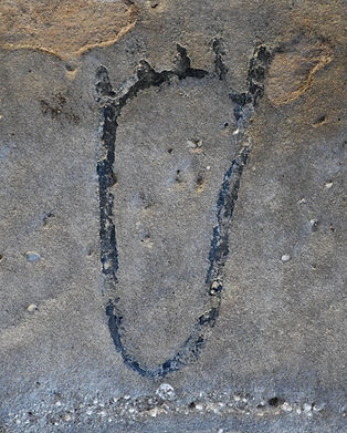
Many petroglyphs in the Ohio Valley are of footprints, sometimes animal, other times human.

The surviving petroglyphs we are about to explore stand as some of the last tangible remnants of an intricate system of communication and spirituality that once spanned the Eastern Woodlands. They remind us that long before highways and written language, symbols carved into trees and stones guided travelers, marked sacred places, and preserved the knowledge of entire nations, possibly for thousands of years, or longer.
Yet, their continued existence is uncertain. Natural erosion, vandalism, and modern development threaten many of these sites. Some carvings that once stood in prominent locations have been buried by shifting landscapes or drowned beneath reservoirs created by dam projects. Others have been irreversibly damaged by careless hands, their meanings lost to time.
For those that remain, efforts to document, protect, and interpret them are more important than ever. Tribal nations, archaeologists, and preservationists are working tirelessly to do this, and we can all help. Visiting these sites with respect, supporting Indigenous-led preservation efforts, and raising awareness about their significance are all ways individuals can help ensure that this symbolic language is not entirely erased, and never forgotten.
As you explore the petroglyph sites that still endure, remember that these markings are more than just ancient art—they are messages from the past, left by those who walked this land long before us. They are echoes of a world where symbols carried meaning as deep as the rivers and as vast as the sky, and they remain an enduring link between history, culture, and the landscape itself, a landscape we now fill with our own symbols.

There are hundreds of petroglyph sites in the Eastern United States (and even more out West), from Florida (and even in Puerto Rico and the Virgin Islands) all the way to Nova Scotia and over to Saskatchewan, down the Mississippi River valley and its tributaries, and deep into the Great Plains. The highest concentration (at least to survive to the present day in the eastern United States) is along the Ohio River Valley, specifically in Ohio, Pennsylvania and West Virginia. However, only a few petroglyph sites are open or accessible to the public. Some of these, as you’ll see, require a spirit of adventure to reach; others require permission from the landowner. A few are kept hidden from the public and are only known as a name in the historical record.
While this article will mention dozens of places to see petroglyphs in the Great Lakes region and beyond, its focus will be to highlight the petroglyphs of the Ohio Valley, a lot of which seem to have been created by a common people, roughly around the same time.
We’ll start, of course, in Ohio and then move beyond.
In his lifetime, Swauger noted 35 petroglyph sites in Ohio, but he always said there are bound to be more…Anybody up for the challenge of finding new ones?

1. Leo Petroglyphs
2. Inscription Rock
3. Barnesville and Barton
4. The Antique Sculptures & Ohio Ceramic Museum
5. The Ogham Petroglyphs
6. Parker’s Landing & Indian God Rock
7. Big & Little Indian Rocks
8. Indian Head Rock
9. Sanilac Petroglyph Historic State Park
10. Grand Traverse Bay Structure
11. Petroglyph Provincial Park
Leo Petroglyphs & Nature Preserve
400 Park Road, Ray
Probably the best-protected and most well-known petroglyph site in Ohio (located beneath a shelter house in a remote area), the Leo Petroglyphs is a panel of rock carvings on a large slab of sandstone that includes 37 figurative drawings (humans, birds, animals, footprints, a fish, a snake and other figures.) One of the most interesting, and probably the most photographed petroglyph is that of a smiling, round face adorned with deer antlers and bird’s feet, possibly representing a shaman.
It is possible that this location was a “Teaching Rock,” but its age and purpose are unclear. As seen in this article, the images at Leo Petroglyphs are very similar to others in the region, including many found in Pennsylvania and West Virginia. Swauger believed they were related.
Along with signage that explains the petroglyphs, this historical park also contains hiking trails that lead through a surprisingly small, yet beautiful gorge with waterfalls. Maybe the beauty and intrigue of this area is why the petroglyphs were carved where they are.
The historic site is accessible from U.S. Route 35, about 9 miles north of Jackson on Sour Run Road. Follow Sour Run for 2 ½ miles, then turn left on Raysville Rd, followed by an immediate left on Park Rd. Watch for signs for the park, less than a half mile on your left. It is open year-round and free to visit.


Leo Petroglyphs is rare because it is an "inland" petroglyph, located near a beautiful ravine in the middle of cattle farms. Most were/are located along the Ohio River and its tributaries. (Photos by Matt Bayman)
Inscription Rock on Kelleys Island
210 E. Lakeshore Dr. Kelleys Island
At one time, this giant slab of rock on Kelleys Island was half-buried in Lake Erie. However, after petroglyphs were discovered on its surface in the 1800s, it was salvaged and exhibited beneath a shelter for tourists to visit while vacationing on the island. Before a quarry was built on the other side of the island there was a second (apparently similar) petroglyph as well, but it was destroyed.
Unfortunately, even though Inscription Rock is protected with a roof, natural erosion and weathering have taken a toll on the petroglyphs, making them very difficult to see. It goes to show that even things “carved in stone” don’t last.
A sign next to the rock shows the design of the petroglyphs in detail. This rock, and possibly the other one on the island, might have been a Teaching Rock.
A ferry or boat is required to reach Kelley’s Island. The ferry is available in Marblehead for a fee. An added bonus on Kelleys Island is visiting the famous Glacial Grooves.


Barnesville Petroglyph
60902 Track Rock Rd., Barnesville
A rare inland petroglyph site, which may point to the nearby Shannon Cave, or was a Teaching Rock, is located at this remote, mostly unmarked location near Barnesville.
Swauger found a total of about 113 different designs on a boulder of sandstone measuring 15 by 11 feet on this wooded hilltop. The symbols are divided into 6 different classifications—47 animal prints (bears, deer, etc.), 26 bird tracks, 21 human body parts (5 faces and 16 feet), 12 geometric figures, 4 snakes and 3 pits (for cracking nuts). Not all of the symbols are still visible, and, as with anything in the open elements, unless this site is preserved, it may not last much longer.
The petrolyph’s location on Track Rock Road was the nickname given to the carvings by settlers and locals.
Although there is no signage or indication of it being there, you are allowed to visit this site. It is marked on Google Maps at “Barnesville Petroglyph.” Just park on the side of the gravel road nearby and enjoy, but don’t touch or disturb the site.


Images of the Barnesville Petroglyphs, also known as the Track Rocks. The site has similarities to the Leo Petroglyphs.
(Photos in the public domain)
Barton Petroglyph
Near Barton, Ohio
The Barton Rock petroglyphs are much harder to visit than most on this list. They are located on a large sandstone boulder in the middle of Wheeling Creek, just south of the Village of Barton. Few people know about this obscure site and there is no signage or indication that it even exists. But, if you have a kayak, are willing to get your feet wet, or if the water is low enough, the site can be visited via Wheeling Creek.
The Barton Petroglyphs were discovered in the 1930s and contain 29 designs, including handprints, turtles, snakes, birds, human stick figures, some thunderbirds and more. It is believed to have been a Teaching Rock, or possibly, due to its extreme remote location, a place where individuals would go to vision quest or experience some kind of initiation.
While the area around Wheeling Creek is private property, the creek itself is not. The massive rock is visible from Google Earth. The coordinates are 40.093479,-80.840064, which is a short wade from the nearby Barton-Blaine Rd. bridge. See images and learn much more about this site HERE.
Independence Slab
Independence Slab, 6624 W. Public Square, Independence
This petroglyph near Cleveland (depicting animal tracks and a crayfish) is unusual for two reasons. First, very few petroglyphs are found in northeast Ohio. Second, the slab of rock the glyphs are located on is part of the foundation of a church—the Independence Presbyterian Church. The slab was discovered in the 1800s when quarry workers were digging in the area. While much of the petroglyph was damaged, a section about 4 by 7 feet wide was cut out and then placed in the rear exterior wall of the church. For years, it was visible from the outside and considered a tourist attraction. However, when the church was expanded, it moved to an interior wall, which now requires visitors to contact the church for permission to view. The number is (212) 524-6307.
Saxon Petroglyphs
Ohio History Center in Columbus
According to Ohio History Connection, the Saxon Petroglyphs were a series of symbolic figures carved into a rock near the banks of the Ohio River near the small town of Saxon. The imagery included animals, such as a bird and bear, but the rock (and glyphs) were already damaged in 1914. To save them, three images were removed and eventually taken to a museum at the Great Circle in Newark, but are now housed at the Ohio History Center, open year-round.
NOTE: Ohio History Connection also has a slab containing petroglyphs from the Kettle Hill Petroglyph site at Kettle Hill Cave in Hocking Hills. A number of unique artifacts were found in the cave, including a mummy and a rare wooden tool.
Written Rock
Clear Creek Metro Park, 185 Clear Creek Rd., Rockbridge (near Hocking Hills)
Almost entirely vandalized by modern (spray-paint) and historical graffiti dating back to the 19th century, the ancient marks (possibly petroglyphs) at this location are thought to have been grooves used by Native Americans to sharpen axes and other tools.
Once inside of the park, the carvings are located in a rock outcrop next to the road at 23233 Clear Creek Rd.
Hand & Eye Petroglyph
Tycoon Lake Wildlife Area, 1703 Tycoon Rd., Bidwell
If you’re looking for a seek-and-find adventure, head to this remote wildlife area near the original Bob Evans farm (not far from Leo Petroglyphs) in southern Ohio and try to find the Hand and Eye Petroglyph on this public property. According to James Murphy in an old “Ohio Historical Society” document, the petroglyph lies within a “rock shelter near Tycoon” and is an example of the “Southern Cult” Hand and Eye motif. It’s made up of four fingers (others from this era sometimes contain three fingers).
The only hints given to the location of the glyph is that the rock shelter is 6 feet deep. From the lay of the land, it would appear to be somewhere on the west or south side of the lake in the deep wooded areas, but your guess is as good as mine.
The Antique Sculptures & Ohio Ceramic Museum in East Liverpool
400 E. 5th St.
Thanks to a man named Harold Barth in 1908, and the good people at the Ohio Ceramic Museum in modern times, images of the famous “Antique Sculptures” petroglyphs that once lined the banks of the Ohio River are preserved for future generations to ponder. They feature more than 200 prints that Barth spent an entire year lifting and transferring to paper from sites at Brown Island, Smith’s Ferry, Babb’s Island, Wellsville and more locations along a 10-mile stretch of the Ohio River near East Liverpool.
There are some amazing and completely rare petroglyphs in the collection, many seen here in this article. They include thunderbirds and water panthers, serpents, turtles, tracks, human figures, and lots of symbols and mythical creatures.
At one time, the physical carvings themselves were a major tourist attraction. However, in the 1920s, the first in a series of dams were built on the Ohio River, with a “super” dam built in the area in the 1950s. When this happened, the “Antique Sculptures” were inundated beneath 15-20 feet of water and were only seen again three times—1940, 1948 and 1958. They’ve never been seen in person again and now only exist as drawings. In September of 2023, shortly after these photographs were taken, Barth’s original etchings were photographed by the museum and then moved offsite for special storage and preservation.
Even though the “Antique Sculptures” and other nearby sites are submerged beneath water, it is fun to drive along the Ohio River to visit some of the islands and locations where— somewhere down there—these petroglyphs still exist. (VIDEO & ARTICLE ON THIS LOCATION HERE)


Islands in the Ohio River, especially in the area around the Ohio/Pennsylvania border, and shorelines in the area were covered with hundreds of petroglyphs. Today, many still exist, only they're under water, or buried beneath mud, possibly never to be seen again.
(Photos by Matt Bayman)
