


Following the Great Miami River
From Start to Finish
Story & Photos by Matt Bayman
If you take a drive north of Indian Lake State Park and locate Township Road 85 in Hardin County, you can pull your vehicle to the side of the road, look across a field to a wooded area on a small hill in the distance and watch as the North Fork of the Great Miami River trickles down the hill on its way to the Ohio River and eventually the Gulf of Mexico.
When the trickle reaches the road, it is diverted like rainwater into a drain that flows beneath the road, through a pipe and then west before entering Indian Lake at Long Island.
At its beginning on Township Road 85, the river looks like a miniature canal and is no wider than a few feet at any one place. It’s surrounded by farmland.
Not far away, the South Fork of the Great Miami River starts in a similar fashion, also flowing into Indian Lake. From here, the Great Miami River forms on the south side of the lake and gains enough momentum to carve its way to the Ohio River, forming the Miami Valley as it goes along. As it does, someone following the roughly 170-mile course will discover that the history and beauty of the Great Miami River makes for an interesting adventure that’s close to home.
For instance, at the mouth of the river, located just west of Cincinnati, is a summit called Shawnee Lookout. A modest hike to the highest point of the hill passes through an ancient Native American earthwork before reaching an amazing view of the confluence of the Great Miami and Ohio rivers. Interpretative signs along the trail inform hikers that this area has been inhabited for at least 14,000 years and that although the earthwork is called Miami Fort, it was not a place of defense, but instead ceremony. A museum at the base of the hill provides more information on the rich history of the area.
Not far from Shawnee Lookout in North Bend, Ohio is the William Henry Harrison Memorial. Located in a secluded, wooded and hilly area overlooking the Ohio River, the monument and park, which includes hiking trails and interpretive signage, is very impressive, as are the other historical sites located near the memorial.
At its northern and southern ends, the Great Miami River flows through the rural and wooded countryside. In between, it passes some of the most interesting towns in Ohio, including many that are close to our homes and hearts. Others may be new to explore, such as the dining, shopping and entertainment district in downtown Miamisburg or the historic district in downtown Hamilton, which is filled with statues, history and famous landmarks. Throw in a family owned amusement park that only opens several times a year, plus dozens of community parks on the river, several covered bridges that span it, and numerous power plants, art museums and roadside attractions located nearby, and following the Great Miami River from start to finish can be a great experience that takes up the better part of two days.
The following pictures represent just some of the interesting things that can be seen when traveling the entire distance of the Great Miami River from Indian Lake to Shawnee Overlook, a distance of about 106 miles as the crow flies.
A number of roads follow the river, so it is possible to navigate by simply following its course by sight. However, a map is required to explore some of the other interesting places found along the way.
These pictures appear in the order they would be seen when traveling south along the Great Miami River from just north of Indian Lake on Township Road 85 to the Ohio River.
Enjoy and drive safely!

1. This is the “start” of the North Fork of the Great Miami River as seen from Township Road 85 near Roundhead in Hardin County. Far from seeming “great” at this point, the water from this stream will eventually flow into Indian Lake, then south to the Ohio River, then along the Mississippi River before reaching the Gulf of Mexico. Just north of Roundhead, rivers flow north toward Lake Erie. This makes this stream the furthest point north on the river. From here, it’s all down hill.

4. The river just north of Indian Lake.

2. A grating next to the hill on Township Road 85 drains the stream beneath the road and then southwest toward Indian Lake.

3. After flowing beneath Township Road 85, the North Fork of the Great Miami River takes shape in the surrounding farmland.

5. North of Indian Lake, the North Fork of the Great Miami River cuts through peaceful and scenic farmland. Pictured here is one such scene at Manchester Farms near Lakeview.

6. The north and south forks of the Great Miami River feed Indian Lake, which is a popular spot for recreation and fun.

8. Located over the Great Miami River about 5 miles south of its source at Indian Lake on County Road 13, the McColly Covered Bridge was built in 1876 by the Anderson Green Company of Sidney, Ohio.

7. The official start of the Great Miami River is here at the Indian Lake Spillway, located on the southern end of the lake. From here, what appears clearly to be a river begins to take shape.

9. A spillway next to the famous The Pines restaurant in the quaint village of Quincy.

10. A long, picturesque railroad bridge spanning the Great Miami River near Quincy.

11. Ducks and geese love to hang out in the pond and river next to (former) Hussey’s Restaurant in Port Jefferson.

12. The Ross Covered Bridge in Tawawa Park spans a tributary of the Great Miami River. It’s beautiful to see any time of year.

13. The Big Four railroad bridge crossing over the Great Miami River on the south end of Sidney.

14. The “Little Four” railroad bridge, just south of Sidney on River Road.

15. Just north of Piqua are some of the highest views of the Great Miami River. Miami River Road and Hetzler Road pass along the rim of a deep valley cut by the river.

16. The Great Miami River winding through Piqua.

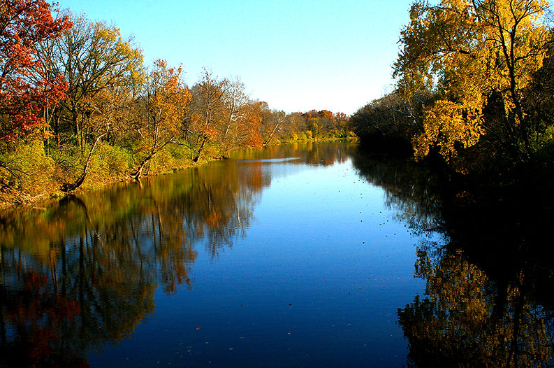
17. The Twin Arches and the Great Miami River on a foggy fall morning.

18. Eldean Covered Bridge over the Great Miami River between Piqua and Troy.

19. The Great Miami River as it approaches Troy, south of Eldean Covered Bridge.

20. A reflection of the lighthouse at Treasure Island Park in Troy.

21. A Sculptures on the Square statue next to a calm, flat section of the Great Miami River next to downtown Troy.

22. The Troy skyline in the Great Miami River as seen from the Market Street bridge in Troy.

23. A fisherman maneuvers the Great Miami River near Barefoot Canoe in Tipp City.

24. The confluence of the Stillwater and Great Miami rivers at Island MetroPark in Dayton. The Stillwater is on the left and the Great Miami on the right.

25. A cyclist follows the Mad River to its confluence with the Great Miami River at Deeds Point, which also contains one of the largest fountains in the world and a statue of the Wright Brothers. Nearby is McCook Field, considered the “Cradle of Aviation Innovation.” It was located directly next to the Great Miami River and is now baseball and softball fields.

26. The Wright Dunbar Monument at the confluence of Wolf Creek and the Great Miami River, just across from downtown Dayton.
(See more photos of the river in Dayton HERE)

28. A colorful wall near the historic district in downtown Miamisburg.

27. The spillway at Miami Bend Park in West Carrollton. At this unique location the river makes a sharp curve and briefly travels north before returning to its southern course. An airport is located nearby.

29. The DP&L Power Plant, just south of Miamisburg.

30. A fountain next to the Great Miami River in Franklin.

31. The Museum of Spiritual Art in Franklin. It overlooks the Great Miami River.


32. The River Center in Middletown. The park features a musical pavilion, a veteran’s memorial and a visitor center.
33. A statue of founding father Alexander Hamilton in downtown Hamilton.


34. A view of the Butler County Soldier’s Monument from the Main Street bridge in Hamilton.
35. The Sticker Grove Amusement Park, a family owned business located just south of Fairfield along the Great Miami River.

36. The William Henry Harrison Memorial overlooking the Ohio River near its confluence with the Great Miami River.

37. The Luminant Miami Fort Power Station at the confluence of the Great Miami and Ohio rivers.

38. Shawnee Overlook, where the Great Miami River meets the Ohio River and the place where the border between Ohio and Indiana originates from. However, the river has meandered a lot since the border was drawn, so it now travels about a quarter of a mile west into Indiana before emptying in the Ohio River.

39. To reach Shawnee Overlook, hikers pass through an ancient Native American (Hopewell) earthwork that was likely used for ceremonial purposes. Interpretive signs along the trail explain the history of the Native Americans in the area. There’s also a museum, Indian mounds, frontier log cabins and other attractions in the park. There is a fee to enter the park.
To view more pictures of life along the Great Miami River, click HERE.
Here are some pics of the Great Miami River in Dayton.


To discover the "start" of the Stillwater River, click HERE.
To explore Fossil Beach, located on the Great Miami River in Tipp City, click HERE.
