


Story & Photos by Matt Bayman

Deep in the rugged hills of southern Ohio, where limestone cliffs rise above forested hollows and ancient earthworks whisper of civilizations past, hikers can immerse themselves in one of the Buckeye Trail’s most remote and rewarding stretches: the Sinking Springs section.
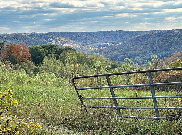
Winding through the wooded ridges and narrow valleys of Highland and Pike counties, this 24-mile portion of the 1,400-mile Buckeye Trail is known for its solitude, steep climbs, and scenic terrain. It offers a challenging but worthwhile day or multi-day hike for those willing to venture off the beaten path—especially in the fall, when the area’s foliage (and stillness) is spectacular.
Established in 1959, the Buckeye Trail—the longest loop hiking trail in the country—was created to showcase Ohio’s natural beauty, linking Lake Erie in the north to the Ohio River in the south, and nearly everything in between. Marked by its signature blue blazes, the trail circles the state through national forests, historic towns, scenic byways, and remote wilderness—like that found in the Sinking Springs section.


Centered around the small village of Sinking Spring—a town founded in the early 1800s near a disappearing natural spring that lies within an ancient meteor impact crater (LEARN MORE)—the trail meanders through densely wooded ridgelines, valleys, and secluded hillsides. Roughly half of the section—about 12 miles—passes directly through Pike State Forest and Pike Lake State Park, which is arguably the best part of the hike and, as we’ll see, a great place to set up camp.
Some parts of the trail follow narrow footpaths and forest ridges, while others take hikers down old farm lanes, long-abandoned wagon roads, and stretches of lightly traveled township roads. This keeps the scenery changing, interesting and, yes, challenging.
Trail surfaces vary—from soft loam to rocky slopes and occasional pavement—so hikers must stay alert. Trail markings can also be sparse or faded in some road-walk areas, making navigation tools essential. It’s also a good idea to check buckeyetrail.org for current trail conditions and/or warnings before hiking.
After crossing State Route 41 (just north of Sinking Spring), a side trail leads to Fort Hill Earthworks & Nature Preserve—home to one of the best-preserved ancient enclosures in Ohio. Built around 2,000 years ago by the Hopewell culture, the massive ceremonial earthwork forms a nearly mile-long wall encircling the top of a 500-foot-high ridge. Visitors can hike up steep but rewarding trails to the ridge or explore paths in the valley below, where natural arches, rock shelters, and limestone cliffs abound.
A short detour west from the main trail (in Adams County) brings hikers to one of Ohio’s (and the world’s) most iconic and mysterious archaeological sites: Serpent Mound. Thought to have been built by either the Adena or Fort Ancient cultures, this massive earthen effigy—shaped like a winding snake that is swallowing an egg or oval—stretches over 1,300 feet along a narrow plateau. Its purpose remains debated, but many believe it served astronomical or ceremonial functions, aligned with solstices and lunar cycles. Visiting Serpent Mound and Fort Hill while hiking this ancient corridor adds a powerful layer of meaning—a direct connection to the people who once walked and worshiped here long before modern trails were blazed.
While there are no designated campsites along the Sinking Springs trail itself, most overnight hikers base out of Pike Lake State Park. The park offers a range of options, from primitive campsites to fully furnished cabins tucked into the woods. After a long day on the trail, hikers can cool off in the lake (one of the cleanest in Ohio), rent a kayak or paddle boat, or simply relax by the fire. Amenities include clean and modern restrooms and showers and a camp store stocked with snacks and trail supplies. The camp office also carries copies of the Sinking Springs trail map and is staffed by some of the nicest people you’ll ever meet!


Pike Lake (with its trailhead) makes an excellent hub for day hikes or section hiking. With a base camp in place, hikers can enjoy the trail without the burden of carrying a full pack—yet still experience the outdoors with the comfort of modern amenities waiting at the end of the day.
For those planning to hike this section, preparation is key. Reliable water sources are limited, so carry plenty of water. Long pants, insect repellent (in the late spring through early fall), and a basic first aid kit are highly recommended to guard against ticks, poison ivy, and other trail hazards. Navigation tools—such as a printed map or GPS app—can be helpful where signage is lacking. Cell phone reception is generally strong, though it may drop off briefly in a few spots, so don’t rely on it completely.
Scenic highlights of the Sinking Springs section include moss-covered boulders, quiet creek crossings, and sweeping ridge-top views of the Appalachian foothills that make this area so serene. Wildlife is abundant too—you might spot white-tailed deer, wild turkeys, turtles, and even bald eagles. On warm days, a black racer snake may be seen sunning itself on the path, so keep your eyes open! And, from recent news, it is now possible to catch a glimpse of a black bear or bobcat, although this is rare.
Overall, what makes this section of the trail truly special is its raw quality. It doesn’t feel manicured or overly managed—it feels like a true backcountry hiking experience, an untouched corridor through one of Ohio’s most ancient and ecologically diverse regions. With Pike Lake as a base camp (and numerous other trails spanning off in all directions), many days can be spent among the quiet beauty of this pristine part of the Buckeye State.
Despite some of the challenges you’ll face on this hike, the reward is profound: deep silence, historic mystery, stunning fall beauty and a renewed connection to the land—and maybe even to yourself. It’s the kind of hike that leaves you tired, muddy, and utterly grateful.
To learn more about hiking this region, or to download a trail map, visit buckeyetrail.org.
Trail Length:
24 miles (point to point)
Approx. 12 miles through Pike State Forest & Pike Lake State Park
Best Time to Hike:
Mid-September to early November (fall foliage peak)
Late April to early June (wildflowers, fewer bugs)
Where to Camp:
Pike Lake State Park – primitive campsites, electric sites & cabins
No official campsites on the trail itself
Essentials to Bring:
Plenty of water or filtration system
GPS app or printed trail map
Long pants & insect repellent (ticks!)
First aid kit
Flashlight or headlamp
Navigation Notes:
Watch for blue blazes
Trail markers can be sparse on road-walk sections
Cell reception mostly reliable, with some gaps
Must-See Detours:
Fort Hill Earthworks & Nature Preserve
Serpent Mound (short drive or extended hike)
Wildlife to Watch For:
Deer, turkeys, turtles, bald eagles
Black racer snakes sunning on warm days
Useful Tip:
Use Pike Lake as a basecamp to section hike the trail in comfort. Hike light and return to a hot shower and campfire.


This section of the Buckeye Trail passes through the Serpent Mound Impact Crater! Learn more by clicking on the image below!
