


+ Visiting the Sites +


TOP LEFT IMAGE: The Newark Earthworks, from a display at the Great Circle Museum in Newark.
TOP RIGHT IMAGE: A copper bird claw made by a Hopewell person, as seen at the Fort Ancient Museum.
BOTTOM LEFT: Hopewell Culture NHP Archives, original painting by Louis S. Glanzman.
BOTTOM RIGHT: A modern (Colonial times) Native American stands next to an ancient Hopewell earthwork. Public Domain.
Story & Photos by Matt Bayman
The people who lived in Ohio 2,000 years ago had a profound understanding of the universe and their place in it. They could look at the placement of the Sun, Moon and stars and know that it was time to plant a certain crop or hunt a certain animal. Their largest religious and social gatherings were held on the summer and winter solstices and during other celestial events. Their symbolism revolved around a fascination with the geometry and cosmic rhythms of the universe and how this relates to the cycles of life and death on the Earth below. They understood the soil and water, the animals and plants, and the land and its resources, and lived in relative harmony with Nature. Even more, they appear to have lived in harmony with each other and their neighbors for at least 500 years and developed a trade network (interaction sphere) that stretched across much of North America, all before nearly being lost to history.
They may have also had a much wider understanding of mathematics and astronomy than first realized.
We call these early Ohioans the “Hopewell” because their artifacts were first identified on a farm in Chillicothe owned by Mordecai Hopewell in 1891. We actually have no idea what they called themselves, as they left no written record. They lived in abundance along the Ohio River* and its tributaries from about 100 B.C. to 400 A.D. and are known today for the giant earthworks they left behind, including a group of 8 works in Ohio that became a UNESCO World Heritage Site in 2023, making them only the 25th such site in the U.S.
* (Note: The Hopewell Tradition spanned across much of what is today the eastern United States and parts of Canada, but Ohio was clearly its most advanced/important location)
Even though earlier cultures had built earthworks for thousands of years prior to the Hopewell, including throughout Ohio, it was they who gave us the largest, most complex structures, including the 3,000-acre Newark Earthworks, which is part of the new UNESCO site and the largest earthen enclosure in the world (depicted below).


TOP IMAGE: A rough, not-to-scale depiction of some of the proposed Moon alignments at the Newark Earthworks. A Hopewell individual would view these sight-lines from high vantage points (usually hills) above the works. The background image was created by CERHA and the lines and descriptions were added by the author based on the work of Robert Horn and Ray Hively and as published on the Ohio History Connection website.
LEFT: Moon alignments discovered by Horn and Hively at the Newark Earthworks.
RIGHT: A depiction of the Moon’s Major Standstill at the earthwork, which only happens every 18.6 years, created by the Center for the Electronic Reconstruction of Historical and Archaeological Sites (CERHA).
What’s amazing about this city-sized earthwork is that it aligns precisely with a complex cycle of the Moon that takes 18.6 years to complete. In particular, the 8 sides of the 50-acre Octagon at the Newark Earthworks (currently part of a golf course) align to the four moonrises and four moonsets that mark the limits of the long cycle. For a brief time every 18.6 years, a Hopewell individual could stand on top of the 20-acre Observatory Circle and watch as the Octagon in the distance came into perfect alignment with the northernmost moonrise on the horizon (seen above right), thus bringing an end to the 18.6-year cycle (known as its “Major Standstill”) and beginning a new one.
(NOTE: The next Major Standstill occurs at the end of 2024 and lasts into the beginning of 2025 - peaking in January - so it will be an ideal time to visit the site)
Archaeologists, including Brad Lepper, the curator of archaeology for the Ohio History Connection, believe the Major Standstill was a major event for the Hopewell, with people traveling from hundreds of miles in all directions to attend, often leaving behind elaborate gifts of jewelry, pipes and artwork—and possibly, as we’ll see, the remains of their loved ones.
About a mile southeast of the Octagon (and part of the same giant structure) is the Great Circle. Just like the Octagon during the Major Standstill, a Hopewell individual could stand in the middle of the 30-acre Great Circle (at a place we call Eagle Mound) at a designated time and watch as the Moon’s minimum north rise aligned precisely with the only opening or “gate” in the circle, thus capturing another key moment in the 18.6-year cycle. Judging from the size and scope of the Great Circle, and the discoveries found within it, this too must have been a monumental occasion for the Hopewell.
If you zoom out from the Octagon and Great Circle and look at the entire Newark complex from above (as it once appeared and as seen in the image above), you’ll notice even more Moon connections. For example, and as noted by author and archaeoastronomer William Romain in his book An Archaeology of the Sacred: Adena-Hopewell Astronomy and Landscape Astronomy, and based on the work of archaeologists Ray Hively and Robert Horn, Observation Circle and the Great Circle are aligned on the axis of the Moon’s south maximum rise, while the Octagon and the center of what we call the Wright Square (20-acres in size) are aligned on the axis of the Moon’s south minimum rise. Also, it's the exact same distance between the center of the two circles as it is between the center of the octagon and square.
In other words, the Newark Earthworks is like a giant machine that tracks and/or mimics or marries the long cycle of the Moon with the ground, with mathematical precision.
It doesn’t stop there. When the Newark Earthworks were first observed and recorded (before settlers destroyed most of the works in the 19th century), a “road” surrounded by thick parallel earthen walls on both sides was found to begin at the Octagon and stretch at least 30 miles to the south in a straight line. Believe it or not, and as put forth by Lepper in a theory known as the “Great Hopewell Road,” it is very likely that the “road” either pointed or led directly to what archaeologists believe was the most important place in Hopewell society, a place we today call Chillicothe. More specifically, it points to Sugarloaf Mountain, which majestically overlooks Chillicothe along Ohio’s glacial boundary—a place where the rolling Appalachian Mountains meet the flat Great Plains, and where huge numbers of Hopewell earthworks were built.
Using a simple measuring tool on Google Earth (and as depicted below), one can place a marker at the edge of the Octagon in Newark (where the Great Hopewell Road begins) and make a perfectly straight line along the “road” to the very peak/center of Sugarloaf Mountain. This is a distance of about 60 miles!
But it gets even better!


ABOVE: By chance or design (no one knows for sure), Sugarloaf Mountain in Chillicothe sits at the geographical center of four of the largest Hopewell sites ever built (white dotted lines added for effect). Additionally, a proposed Great Hopewell Road may have connected the Newark Earthworks with Chillicothe. Chillicothe was like the Hopewell capital, while Newark was like its “Mecca.” The two areas were visited by people living throughout North America some 2,000 years ago. NOTE: This represents only a fraction of the earthworks built by the Hopewell throughout the Ohio River Valley.
Earthwork images by Squire & Davis, public domain.
Romain and other archaeologists have noted that Sugarloaf Mountain was like the axis mundi (center of the universe) for the Hopewell, at least when it came to creating and aligning the dozens of earthworks they built in and around Chillicothe, and along the Scioto River and Paint Creek, and possibly far beyond.
In his paper, “Adena-Hopewell and the Milky Way Path of Souls,” Romain notes that at least five earthworks in the immediate vicinity are situated so that a significant solar or lunar event will appear over Sugarloaf Mountain when viewed from the respective site. For example, viewed from the southeast gateway of Hopeton Earthwork the summer solstice sun will rise over Sugarloaf Mountain.
Using the same Google Earth tool, it is astonishing to discover that a straight line can be drawn in all four cardinal directions from the peak of Sugarloaf Mountain (depicted above), with each line leading to a major Hopewell earthwork many miles away. For starters, over 70 miles to the east of the mountain was the giant Marietta earthworks (and the confluence of the Ohio and Muskingum rivers, which leads to Newark). About 45 miles due south were the impressive Portsmouth earthworks, which spanned across the Ohio River into Kentucky near its confluence with the sacred Scioto River. About 60 miles due west is the giant Fort Ancient earthwork on the Little Miami River in Warren County. And, last but not least, about 15 miles due north is Circleville, which gets its name from the massive circular earthwork that the town was built on top of.
In this sense, Sugarloaf Mountain was the place at the center of the four directions. It was home.
Knowing this, it is not surprising to learn that Chillicothe is where the most Hopewell burials have been discovered (often with the most elaborate burial items), including within what used to be called “mound cities,” that is, burial mounds surrounded by earthen walls that themselves are often aligned with various celestial points, usually related to the Sun. These sites are now part of the Mound City Group in Chillicothe, which is operated by the National Park Service and also part of the new UNESCO site in Ohio, as is Fort Ancient.
Additionally, as discovered by Hively and Horn in the 1980s, and further developed by Romain and others, almost all of the Hopewell earthworks, from those found in Chillicothe and Newark to Fort Ancient and throughout the Ohio River Valley, appear to use a common form of measurement that equals 1,053-feet, and divisions thereof, not to mention the same kinds of earthen circles, squares, shapes (and sizes), walls and roads. In other words, they were all doing roughly the same thing, around the same time, using a shared common knowledge, mathematics and method.


ABOVE:
Common shapes and measurements can be found at Hopewell sites throughout Ohio (and beyond). Earthwork images by Squire & Davis, public domain.
So, what we are now beginning to comprehend is that the Hopewell had an understanding of astronomy and mathematics (and apparently surveying) that was on par with many other major societies of their time, including the Romans, Chinese and Persians.
However, as we’re about to see, the Hopewell were not using their knowledge and technology in the same way as their counterparts across the ocean, who, at this time, were almost in constant states of warfare and rebellion.
What Were the Hopwell Up To?
We may never know for sure what purpose the Hopewell’s giant astronomically aligned earthworks served, or how they came to understand and communicate complex mathematics without a system of writing, or to build such works without large-scale cities/civilization (the Hopewell lived in extended family groups, rather than in organized villages), but most archeologists and anthropologists agree that, whatever it was, it seemed to be driven by religious or spiritual beliefs, rather than a desire to understand mathematical concepts and build machines, weapons and gadgets.
Like Plato before them, who wrote that god must be a geometer, or Newton after, who saw god as a watchmaker, the Hopewell seemed to be concerned with the mechanics and cycles of the heavens and Earth and how these things related to their lives...and deaths.
Which brings us back to the Great Hopewell Road.
Lepper, as well as Romain and others (guided by Native American traditions that carry-on to this day) have postulated that the Great Hopewell Road, and the earthworks found in Newark and Chillicothe was in fact an earthly representation of the Native American concept of the Path of Souls. In short, they believe the earthworks and mounds (and road) were likely associated with spiritual or ceremonial practices and may have symbolized the journey of the deceased to the afterlife in the Hopewell belief system.
In his paper “The Milky Way Path of Souls and Adena-Hopewell Earthworks,” Romain explores the idea that the Newark Earthworks, Great Hopewell Road, Mound City, Serpent Mound (located not too far away), and others were part of “a dynamic relational web related to the Milky Way Path of Souls and journey of the soul to the Land of the Dead. Each site ‘did’ something in the sense of enabling, facilitating, guiding, constraining or otherwise affecting the movements and experiences of people, living and dead along the Milky Way Path.” Romain adds, “The sites considered span a distance of about 89 miles across south-central Ohio. As such this relational network may be one of the world’s earliest and longest metaphorical representations of the journey of the soul after death.”
Lepper believes that Newark was literally the “Mecca” of the Hopewell and that, periodically, tens of thousands of people with common beliefs and practices traveled hundreds of miles (and longer) to attend pilgrimages in the Hopewell heartland in Ohio, and possibly to partake in some kind of “Milky Way Path of Souls” ritual involving the dead, and also trading and mingling.
We know they came from far and wide because of the “gifts” that many of them left (or were buried with) in Newark and Chillicothe (and other places). This includes items with shark teeth from Maryland, lightning whelk shells all the way from Naples, Florida, copper from Ontario, megalodon teeth from the Gulf of Mexico, mica from Tennessee and, maybe most impressive, obsidian from a place called Bear Gulch in western Idaho (1,700 miles away as the crow flies) and from Yellowstone National Park, among other far off tricks of the trade.
The bottom line is that whatever was going on in Newark and Ohio was a big deal!
Lepper, Romain and others have written extensively about what they believe the Path of Souls meant to the Hopewell and how it may have “worked.” In short, most archaeologists believe that the Hopewell brought the remains of at least some of their dead to the Newark Earthworks where they took them through a series of rituals that involved the massive earthworks, possibly during specific times of the year. This process may have involved cremation for some of the remains (others were found fully interned). Afterwards, the family would use the Great Hopewell Road to ceremonially walk their loved ones along the Path of Souls to be interned in the center of their universe in Chillicothe, possibly in a “mound city.”
As Romain discovered, there may have even been an ideal time to make this pilgrimage/journey. After doing the measurements, he found that the Great Hopewell Road aligns with the Milky Way (which arches over the dome of our sky from one end to the other) on the evening of the summer solstice sunset, thus spiritually and cosmically connecting Newark, Chillicothe and the heavens during this significant and profound moment.
Many modern-day Native American tribes refer to the Milky Way as a place of creation or, like the Lakota Sioux, the celestial road where the souls of the deceased travel to reach the spirit world, i.e. The Path of Souls.
With plenty of evidence for large-scale fires at many of the earthworks in Newark (and other locations), the smoke from the funeral pyres during these times may also have symbolically lifted into the heavens, eventually blending in or joining the smoky path of the Milky Way in the night sky, possibly just after the summer solstice sunset when everything locked in place or opened up.
All of this speculation doesn’t even take into account the potential significance of what each Hopewell shape may have stood for, if anything. Romain believes that the large squares represent the heavens/Sun, the large circles are the Earth, and the octagon, of which there are only two (in Newark and Chillicothe) is the Moon. These shapes were often connected by roads that aligned with the solstices and other celestial markers, as well as walls. It also doesn’t take into account the thousands of other earthworks that were scattered all over the place, some with extremely unusual shapes, with one that stands out being the East Fork or Hanukkiah Earthwork near Milford, Ohio (pictured below)—named so because it looks like a menorah surrounded by a lamp! The unique layout of the Portsmouth, Ohio earthworks and the Temple Mound (seen above) are also intriguing and appear to be just as massive and complex as Newark. (Sadly, they’re all but gone today).


LEFT: The East Fork or Hanukkiah Earthwork near Milford, Ohio was named so because it looks like a menorah surrounded by a lamp. No one knows for sure what the shape meant or represented, if anything.
Image Squire and Davis, public domain.
RIGHT: Image of prehistoric sites in Ohio from the signage at The Seip Earthworks
If the Newark and Chillicothe earthworks had a function, what were the functions of the other earthworks in the Ohio Valley, which were often “packaged” or grouped together at various locations and contain numerous celestial alignments, shapes and features? And, how did they all “work” together, if they did at all?
It’s fun to think about the birds-eye view of Ohio at this time. The landscape, which was mostly forest, would be periodically broken up by these massive well-landscaped earthworks (and hilltop enclosures), with roads and paths interconnecting many of them and possibly laid out in relation to each other (and celestial points) over distances of hundreds of miles, accurately. It would look like a giant circuit board or architectural blueprint of some kind. While no Hopewell lived in the earthworks, they lived around them and along every major river and stream in the Ohio River Valley.
How Did They Do It?
As mentioned earlier, the Hopewell didn’t live in towns or communities filled with institutions and “government.” Instead, they lived in small groups, working their farms, fishing and hunting and gathering. Yet, they were able to organize and work in unison to build these giant earthworks, not just in Chillicothe but at thousands of locations in the Ohio Valley, voluntarily moving millions of tons of soil. They were also able to pass along a complex form of mathematics and astronomy to generations of people living in a widespread area without writing. They likely did this through oral traditions and storytelling, ceremonies, festivals and rituals, community learning, a large interaction sphere (that traded in knowledge) and, simply put, by direct observation, passed down from mother-to-daughter, father-to-son, generation after generation. It was a way of life that appears to have been shared and mimicked by tens of thousands of people in Ohio and beyond for ages.
It is not known what happened to the Hopewell. After about 500 A.D., they disappear from the archeological record in Ohio. They likely spread out in new areas and cultures, with some evolving into what we call the Fort Ancient people (1000-1650 A.D.), who may have built Serpent Mound and many other earthworks, and others moving west and south to eventually become the Mississippi people (800-1600 A.D.), who built the largest pyramid north of Mexico (Cahokia) near modern-day St. Louis, among many other earthworks. Many more may have stayed behind in Ohio and began cultivating corn and living communally, eventually losing interest in mound building. These later groups were still present when Christopher Columbus arrived in 1492, which means that, likely, the meanings and traditions associated with mound structures and the rituals that surrounded them, similar to Hopewell times, was still common knowledge among the general population at that time.
However, as history goes, when the Spanish introduced diseases to the “New World,” it is estimated that about 80 to 90 percent of the Native American population (possibly up to 100 million people) were wiped out on both continents, in as little as two centuries, with most of the damage coming in the first hundred years. With so much death and stress, and no written record, it seems the message of the earthworks and their meaning was disrupted and almost lost to history.
Many of the Native Americans who moved into Ohio after the Hopewell and For Ancient traditions were just as perplexed by the earthworks as the European settlers who came after them. They didn’t know who built them or what purpose they served.
With little consideration, settlers in the 1800s plowed over a majority of the earthworks and cities were built on top of the former massive earthworks, largely because the Hopewell and the Adena before them had scouted out the best places to live in Ohio thousands of years ago, which were also ideal to settlers. Eventually, besides a few locations, most evidence of the Hopewell was erased and looted and their culture and accomplishments were considered but a side note in history, if mentioned at all.
However, we now know, and are beginning to fully appreciate, that 2,000 years ago, Ohio was a special place to be, and possibly one of the most ideal places on the planet to be alive at the time. It was a place (and time) filled with peace, unity, abundance, travel, creativity and a connection to Nature and the heavens. It was a place where technology was used to try to understand the complex situation we find ourselves in, rather than to destroy each other. Which doesn’t sound too bad.
Visiting the Sites
Just a few days before the fall equinox in 2023, when night and day are equal in length and the Sun rises due east and sets due west, I set out to explore the ancient Hopewell earthworks and related sites in Ohio, as well as a few sites with disputed creators and dates of completion. Since there are so many of them, this took several days to complete.
On my phone I have a free app called SkyView Lite that allows its users to track the locations of celestial bodies in the sky and their setting points on the horizon, such as the Sun, Moon, planets and stars (even during the day) and to determine the direction I’m facing when looking at a live image on my screen, such as a landscape or earthwork. This tool, along with a few books by Romain, Lepper and others, allowed me to experience many of the earthworks in a new and profound way, thus bringing an even greater appreciation for the accuracy and methods of the Hopewell.
As you’re about to see, around every corner, the earthworks that the Hopewell and others built just keep lining up in the most amazing ways.
Tarlton Cross Mound
Just by chance or good fortunate, the Sun was about to set when I arrived at Tarlton Cross Mound in rural Fairfield County. I was the only person at the park and enjoyed a hike to the earthwork that began by crossing an old stone bridge built in 1936 and then entering a lush patch of woods. After a short walk, visitors come to a small fenced-in area that contains the earthly shape of a plus-sign effigy. It spans about 90 feet across on the ground, with a depression in the middle of the work. While early settlers saw a cross, it actually represents and aligns (roughly) to the four cardinal directions.
The first thing I did was walk to the east side of the earthwork and opened SkyView Lite on my phone. I pointed it at the earthwork (looking west) and lined it up on my screen. Sure enough, it showed that, as this was the autumn equinox, the path of the setting Sun would soon intersect with the “cross’s” western arm on the horizon, which also happens to be due west. It will do the same thing every spring and fall equinox for a long time to come!
No one knows for sure what purpose the effigy served, but it has been noted that the Great Hopewell Road passed near Tarlton Cross and that the effigy sits roughly in the middle of the great Newark Earthworks and those in Chillicothe along that route. Was it a road mark or mile marker to help guide the way?


Flint Ridge
People have been coming to Flint Ridge in Ohio for as long as they’ve been in the region, which is at least 14,000 years. Below the surface here (not far from the Newark Earthworks), is a 10-by-3-mile slab of Ohio’s famous Vanport Flint, which was treasured by Native Americans for its workability into spear points and tools and the brilliant shades of red, green and blue that it turns when heat-treated. Worked pieces of the flint have been found in burial mounds as far away as the Gulf of Mexico, St. Louis, Arkansas and Wisconsin, demonstrating that it was a treasured commodity.
Archeologists believe that no one group controlled the quarry and that it was shared by many different people who came from far and wide to quarry the stone and possibly to trade. It has been called the “Great Indian Quarry of Ohio” and was no doubt important to the Hopewell. It may have been one of the reasons Newark was chosen as the site of a great Hopewell earthwork.
To this day, visitors can see the deep pits that Native Americans dug out over time, including large pieces of flint that were left on the ground. Some of the pits have filled in with water and now provide habitat for plants and amphibians. A short hiking trail leads through the quarry and includes a variety of informational kiosks that tell the history of the site and its users.
A museum at the site is open 10 a.m. to 4 p.m. Thursday-Saturday, while the hiking trails are open daily year-round.


Miamisburg Mound
There is possibly no better view in Dayton than from atop Miamisburg Mound. Built by the Adena more than 2,500 years ago, the mound is one of the two largest conical mounds in eastern North America. A set of stairs allows visitors to climb to the top to enjoy the panoramic view between dusk and dawn, which are both great times to be there!
It’s interesting to learn that, at one time, the mound was covered by a “roof” of stones, as were many other mounds in Ohio and beyond.


Alligator Mound
I arrived at Alligator Mound in Granville fairly early in the morning. I was surprised to find that the earthwork is located in the middle of a cul-de-sac lined with beautiful homes, several of which have a panoramic view of the valley below, a valley that happens to contain the nearby Newark Earthworks. These same views (and elevated position among the stars) must have attracted the Moundbuilders to the site long ago.
Although first attributed to the Hopewell, Lepper believes the effigy (misidentified by settlers as an alligator and more likely a possum, constellation or spirit animal) was more likely built by the Fort Ancient people who came after the Hopewell. He also believes Serpent Mound was built by the same people. The two effigies certainly have a lot in common, including curled tails that appear to be astronomically aligned.
According to Jeff Gill of the Ohio History Connection in his paper, “The Archaeoastronomy of Alligator Mound,” “if you stand at the end of the spiral at Alligator Mound, whether your own shadow or a staff in hand, you cast a line on the vernal equinox that at sunrise arcs across the body of the Alligator, south of the former stone altar, and cuts right across the northwest, right front forepaw of the effigy. In fact, the same exercise at sunrise will show a very rough alignment from the spiral center to the right rear paw platform at the winter solstice sunrise, or to the left rear paw platform at the summer solstice sunrise. And you get equally intriguing results at sunsets, as is astronomically always the case, echoing back in the opposite directions.”
The SkyView Lite app confirms these measurements, as well as other interesting features at the effigy.
(Aerial photograph from Ohio History Connection)


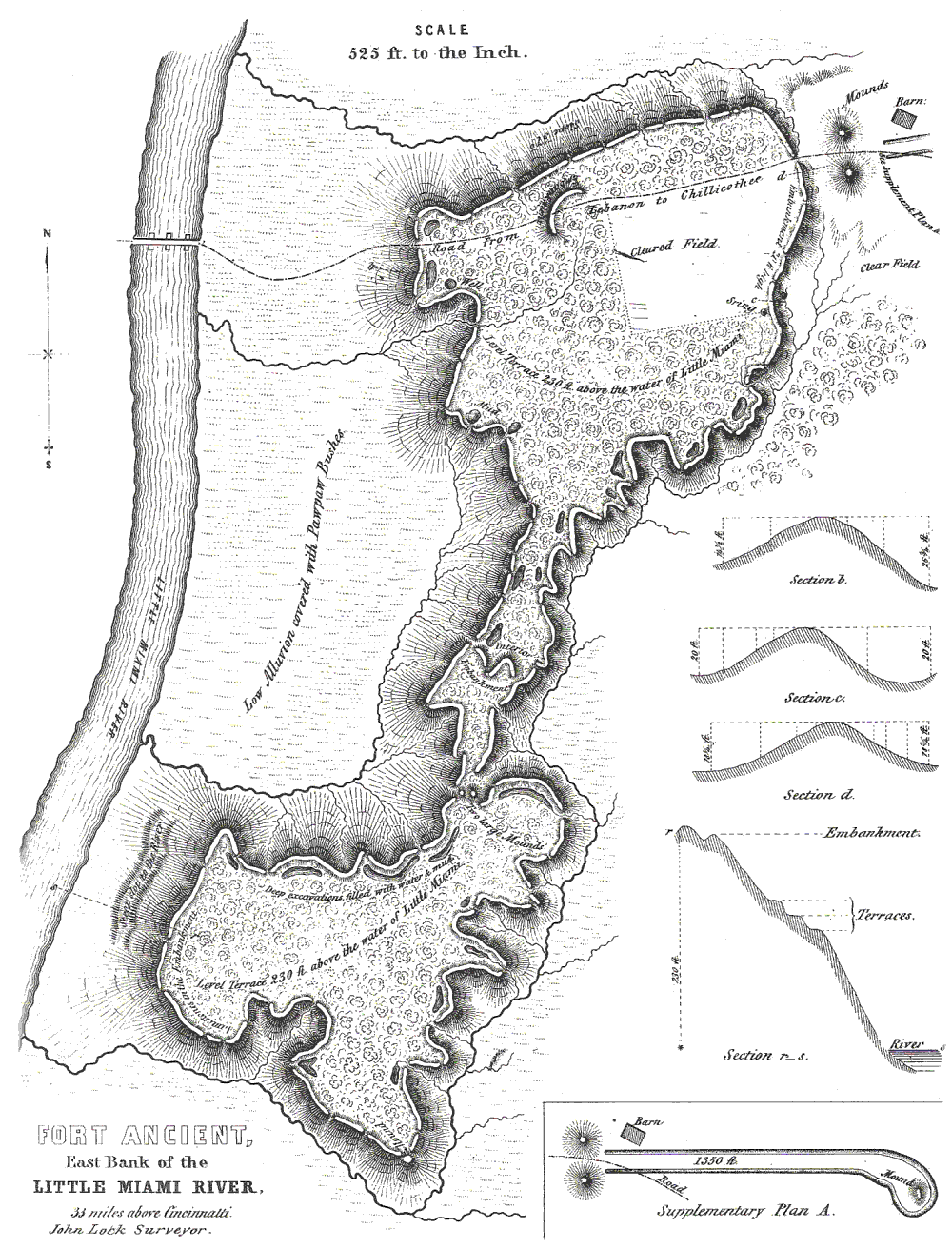
Fort Ancient
Fort Ancient is Ohio’s oldest state park and the largest hilltop enclosure in North America. Although first attributed to the Fort Ancient culture, it was in fact built by the Hopewell some 2,000 years ago.
Just like Fort Hill, Fort Ancient was not a strategic fort, but a ceremonial structure that contains a variety of celestial alignments, including some that appear in the 67 “gates” found along the perimeter of the massive structure. As noted by Romain in An Archaeology of the Sacred: Adena-Hopewell Astronomy and Landscape Archaeology the entire structure is centered on the summer solstice sunrise, with the center of the “fort” and a giant square made up of four stone-covered mounds on the north side of the structure pointing at the summer solstice sunrise.
Additionally, a set of low parallel walls that once extended from the north gateway of the “fort” for about 2,700 feet also captured the summer solstice sunset.
There are many other alignments in the earthwork, including to the winter solstice and the phases of the Moon.
The Museum at Fort Ancient offers 9,000-square-feet of detailed exhibitions and is included with admission to the grounds.


Newark Earthworks
The best time to visit the Newark Earthworks is during one of several open houses held by Ohio History Connection each year, usually in April and October. However, this will soon change.
In 2022, Ohio History Connection won a court battle with a private golf course that has been leasing the Octagon portion of the earthwork for many years that will require it to vacate the property. A full-scale park honoring the earthworks will soon take its place.
Until then, the nearby Great Circle and Great Circle Museum is completely open to the public and allows visitors to get a good feel for the magnitude of the city sized earthwork and the people who created it. A variety of signage on the grounds helps visitors understand what they’re looking at. The museum offers even more information. It is open 10 a.m. to 4 p.m. Thursday through Saturday at 455 Hebron Rd.
Knowing the different alignments associated with the property and having the SkyView Lite app to put them in perspective adds to the experience of a visit.


Mound City Group & Hopewell Culture National Historic Park
I had the pleasure of visiting Mound City Group in Chillicothe at sunset and sunrise over a two-day period just before the autumn equinox. The sunset was most remarkable, with the glowing sky bathing the 23 burial mounds within Mound City Group (known as the “City of the Dead”) with orange light and casting a variety of shadows that slowly moved across the landscape in unique, yet predictable paths.
As noted by Romain in An Archaeology of the Sacred: Adena-Hopewell Astronomy and Landscape Archaeology, the entirety of Mound City Group (located on a flat plain next to the Scioto River) is orientated to the nearby mountain range to the east, which contains the sacred Sugarloaf Mountain. In short, Mound City sits directly in the middle of the mountain range, which contains three key features. First, from the center of Mound City Group, a person looking east at the mountains could watch the sun rise from Mountain Logan (the furthest hill to the south in the range) on the winter solstice and, six months later, rise from Sugarloaf Mountain (the furthest hill north) on the summer solstice. Or, as during my visit, during the equinoxes, the sun will rise directly over the middle of the mountain range at Bunker Hill as seen from Mound City Group.
The celestial alignments don’t stop there. For instance, and as noted by Romain, the “mound city” is aligned to the summer solstice sunset along its diagonal axis in one direction and to the trajectory of the Milky Way along the opposite axis! This again plays into the Milky Way “Path of Souls” concept mentioned earlier.
Mound City Group is one of the five sites making up the UNESCO designation in Chillicothe, with the others being the Hopeton Earthworks, the High Bank Works (currently closed to the public) and Hopewell Mound Group, each of which has its own unique celestial alignments. The other is Seip Mound, discussed next.
A museum at Mound City Group (free to visit and open 7 days a week) is a great place to start when visiting the region or wanting to learn more about the Hopewell.


Seip Mound
Seip Mound is located just outside of Bainbridge (not far from Chillicothe) along Paint Creek, as were several other Hopewell earthworks, including one that looks like a giant bear paw with its claws out and a massive earthen enclosure known as Spruce Hill Earthwork. It is believed that several of these works are aligned together on the axis of the Moon’s minimum north rise, as well as the solstices. However, only Seip Mound is open to the public.
During the past several years, great lengths have been taken to improve the Seip Earthwork site, including groundskeepers mowing around the shapes of the earthwork and allowing wildflowers to grow in the spaces between (see below). In the late summer, the yellow goldenrod wildflowers really make the shapes stand out. A kayak access point also has been added.
The most striking feature at the park is the mound at the center of the giant earthwork, seen at right. It was one of the largest ever built by the Hopewell and contained numerous burials, as well as exotic burial items.
The SkyView Lite app shows that the large mound faces due north and south and that other shapes also fall on specific axes related to the Sun.
One also can’t help but notice that the large loaf-shaped mound looks a lot like the rolling foothills in the area, as if they were trying to mimic the mountain range.


Fort Hill
It takes a little effort to reach and fully appreciate Fort Hill. Located in one of the most beautiful parts of Ohio in Highland County, the “fort” (actually a ceremonial work) sits on top of a protruding hill in a 1,300-acre park. It is only accessible by hiking more than 2 miles into the woods and climbing 500 feet in elevation. While the views are mostly blocked in summer and fall, they are very clear in spring and winter and worth the effort.
Just like Fort Ancient, there are “gates” (33 of them) along the edge of the work. It is not clear what purpose they served. In fact, not much is known about this earthwork.
Romain has calculated that the “lookout promontory” (a place on the hill that hikers enjoy reaching) provides a unique unobstructed view of the summer solstice sunrise over the distant mountain range.
The walls of the “fort” appear to have once been covered in stones and enclosed an area of 35 acres of land that spanned 1.5 miles.


Serpent Mound
It is up for debate who built Serpent Mound and when, but, regardless, it is filled with alleged alignments and symbolism—more than can be dealt with here. The most famous is that the head of the serpent (with its mouth opening to swallow an oval shape) points to the summer solstice sunset. Some believe the curves of the serpent’s body point to the summer solstice sunrise, equinox sunrises and winter solstice sunrise, while others believe they point to phases of the Moon. Still others believe the coil of the tail features alignments and similar shadow-effects to that of Alligator Mound.
With the SkyView Lite app in hand, one can attempt to find answers to these questions, all while experiencing the beauty and mystery of Ohio’s Moundbuilders and some of the most intriguing ancient sites in the world.


