PICTURED HERE:
Situated behind a barbed-wire fence in an unassuming Dayton neighborhood, these buildings were once part of the Manhattan Project.
This may be the most unpleasant travel article I’ve ever written, which was certainly never my intention. I wanted to write a fun and light-hearted piece about visiting Ohio’s “top secret” and “forbidden” places, like the old Nike missile silo near Hueston Woods State Park (built to deflect an attack from the Soviet Union during the Cold War) or the NASA Glenn Research Center in Cleveland (where gravity is defied for public and classified reasons)—both of which are open for tours on a limited basis and loaded with interesting, often secretive history!
But the further I dug into these places—and the reasons why they are top secret or forbidden—the more I realized there’s a much deeper, darker story to tell, one that, although disturbing, needs to be told. And, yes, if you really want, you too can go visit many of these places in person, if only to see for yourself.
Places like the Fernald Preserve & Nature Center, located just outside of Hamilton, where our story—and road trip—begins.


All things considered, Fernald Preserve may be the most expensive park in U.S. history. The transformation of the former Fernald Nuclear Site into a public nature preserve cost taxpayers more than $4.4 billion. Adjusted for inflation, the project rivals—or surpasses—the original construction costs of some of the most iconic recreational destinations in the country, including Yellowstone National Park!
But the staggering price tag has little to do with the park’s 7 miles of hiking trails or its modern visitor center. Instead, it stems from the extraordinary cost of remediation: the removal of more than one million tons of radioactive waste, 31 million pounds of nuclear metal products, and an estimated 51 billion gallons (and counting) of contaminated groundwater from the 1,000-acre site.
Between 1951 and 1989, the Fernald Nuclear Site served as the primary U.S. facility for converting raw uranium into weapons-grade material, and later into fuel for nuclear reactors. During the height of the Cold War, it supplied roughly 60 percent of the nation’s weaponized uranium, making it a cornerstone of national defense and a major employer for western Ohio. It also likely did irreversible damage to the environment.
According to EPA records, more than 340 tons of radioactive uranium dust was released into the atmosphere during the site’s operation, contributing to a significant increase in local cancer rates. Beneath the preserve—and extending as far as a mile south—lies a massive plume of contaminated groundwater, uncomfortably close to the Great Miami River and its aquifer, which provides drinking water to over a million people! Federal plans call for the plume to be pumped, treated, stored, and monitored for thousands, possibly tens of thousands, of years before it can be considered safe—if it ever truly can be. In this sense, the price tag for the park has just begun!


At the top of this section: An aerial view of the Fernald Feed Materials Production Center during its heyday and (directly above) what it appears like now. The giant mound on the right (and below) has more than 2.9 million cubic yards of contaminated soil entombed in it!


Today, more than 2.9 million cubic yards of contaminated soil lie entombed on site, forming a massive disposal mound that is plainly visible from the parking lot and visitor center.
Taken together, these realities make a visit to Fernald Preserve & Nature Center a reluctant experience!
Located at 7400 Willey Rd., visitors are first greeted by an Ohio Historical Marker identifying the site as “the first link in America’s nuclear weapons production cycle” and noting that it is among the largest environmental cleanup and ecological restoration projects in American history. Once inside, guests can hike a network of trails, including the interpretive Weapons to Wetlands Trail, and learn more at the Visitor Center, which is free and open 9 a.m. to 5 p.m. Wednesday-Saturday and noon to 5 p.m. Sunday.
Throughout the preserve, posted warnings advise against pets, fishing, disturbing the soil, or entering restricted areas—a quiet reminder that beneath the restored wetlands and prairie grasses, Fernald’s past is still very much present. LEARN MORE


Right now, Meta—the parent company of Facebook—is looking to build a massive data center at this former nuclear plant. One of the most polluted places in Ohio, the site is off limits to the public, which, as you can see here, is clearly made known.
Not far from Fernald Preserve sits another Cold War relic—one that is larger, more secretive and still very much alive in public debate: the former Portsmouth Gaseous Diffusion Plant in Piketon.
Drive south along U.S. 23 next to the Scioto River and the footprint of the plant is hard to miss. The complex stretches across the landscape like a fortified industrial city, ringed by fencing, surveillance and stark warning signs bearing the seal of the U.S. Department of Energy. Access roads are monitored, gates are locked, and the facility remains closed to the public. Unlike Fernald—now a wildlife refuge—this site still has a great deal of unfinished business (and pollution) to address.
The uranium enrichment plant opened in 1954 at the height of the Cold War and operated until 2001, supplying material for nuclear weapons and commercial power generation. At its peak, its electricity consumption rivaled that of a major American city and was powered largely by coal-fired plants across the Ohio Valley.
Today, the site is undergoing a complicated transformation. Federal cleanup crews continue work across the property, while Meta—the parent company of Facebook—and advanced nuclear technology firm Oklo have announced plans for a 1.2-gigawatt nuclear-powered data center campus designed to support artificial intelligence operations. If completed as proposed, the project would be among the largest of its kind and could be operational by 2030.
But the story here is layered.


State and federal records document decades of uranium- processing contamination in the area, the extent of which is not fully known. In 2019, radioactive residue was detected inside nearby Zahn’s Corner Middle School, prompting its closure and enraging the community.
Whistleblowers have alleged that, among other violations, plant operators vented uranium and other substances into the night air—releases reportedly referred to internally as “midnight rockets.” Environmental studies have also documented multiple groundwater contamination plumes beneath and around the property. Massive steel cylinders, each weighing roughly 14 tons and once used to store uranium hexafluoride, remain on site and may already have leached into the environment.
Thousands of former workers have filed claims through federal compensation programs alleging exposure to hazardous materials, and hundreds of millions of dollars in medical benefits and settlements have been paid. Likewise, residents have filed numerous lawsuits.
Contamination may also have reached far beyond the site’s borders. In the 1990s, the facility was linked to a classified metals-recycling program that allegedly allowed contaminated materials to enter commercial supply chains.
The list goes on.
For travelers interested in this historic (and controversial) site, there is no visitor center, no guided tours and no hiking trails to explore. In fact, the only way to catch a glimpse of what’s going on here is to drive along McCorkle Road, which crosses a ridge overlooking parts of the plant. From the roadside, the concrete, fencing and lighting create an unmistakable “top secret” atmosphere that feels less like history and more like something still in the making.
Which it is.
Today, the same ground that once fueled the Cold War is now being positioned to power artificial intelligence—another technology shaping the future in ways we are only beginning to understand. Whether we repeat the mistakes of the past or become better stewards of the land and community remains to be seen.
For now, the humming infrastructure behind the fences and barriers stands as a reminder that Ohio’s nuclear story is, in fact, still evolving.


The former Cold War-era Mound Laboratories in Miamisburg, on a cold day.
Before Los Alamos became synonymous with the birth of the atomic bomb, critical work on the nation’s first nuclear weapon was already underway in Dayton.
In 1943, the Manhattan Project launched what was known as the Dayton Project, a highly secretive operation run by Monsanto Chemical Company to develop and refine polonium-210 for use in atomic weapons. The work, secretly conducted in converted buildings in and around Dayton (many still in existence), marked some of the earliest operational research tied directly to the bomb program.
Scientists in Dayton were tasked with extracting and purifying polonium from uranium-processing residues and manufacturing a neutron initiator—a small device placed at the core of the plutonium bomb. When compressed during detonation, the initiator released a burst of neutrons that triggered the chain reaction and explosion. The device was essential to the success of the bomb dropped on Nagasaki in August 1945.
Rather than being built in a remote desert, the project operated out of ordinary structures, including a former playhouse, a downtown warehouse, a space at the University of Dayton and others. The inland location was considered safer from potential coastal attack during World War II, and Dayton’s industrial infrastructure and research capacity made it a practical choice, as did its proximity to Wright-Patterson Air Force Base.
The highly top secret work involved some of the most dangerous radioactive materials known at the time, including polonium, radium and uranium residues. According to historians, safety standards were limited by the urgency and secrecy of wartime research, and many people got sick. Decades later, several sites required federal environmental assessment and cleanup due to radioactive contamination.


Visitors to Carillon Historical Park can now explore local Cold War history at the Mound Cold War Discovery Center, a permanent exhibit dedicated to the former Mound Laboratory and its employees in nearby Miamisburg. Exhibits preserve artifacts, photographs and stories from the nation’s first post–World War II Atomic Energy Commission site and explores how the facility contributed to the Cold War, the Nuclear Age and the Space Race. It includes artifacts, interactive displays and a talking animatronic figure of Dayton Project leader Charles A. Thomas (seen here), a key figure in the region’s early atomic research. Open to the public from 9:30 a.m. to 5 p.m. Monday-Saturday and noon to 5 p.m. Sunday and is included with regular admission to Carillon Historical Park. (Top photos provided)
After World War II, the federal government consolidated these scattered operations at a “purpose- built” facility in nearby Miamisburg. Established in 1948, Mound Laboratory became a key component of the nation’s nuclear weapons complex during the Cold War, as well as a controversial clean-up site.
Located near the prehistoric Adena earthwork known as the Miamisburg Mound, the laboratory initially continued polonium work before shifting to nuclear weapon detonators and other weapons-related components. The facility also developed radioisotope thermoelectric generators, which provided long-term power sources for satellites and deep-space missions, including NASA’s Pioneer and Voyager spacecraft.
At its peak, Mound Laboratory employed thousands and played a significant role in both military and space-related nuclear technology. It was also here that Russian spy George Koval infiltrated the project, speeding up Russia’s response to our program.
Like many Cold War-era facilities, however, the site later faced environmental challenges and lawsuits. Soil and groundwater contamination led to extensive cleanup efforts beginning in the 1990s. The U.S. Department of Energy closed the facility in 2003. Many buildings were demolished, and the property was redeveloped as the Mound Business Park, as it stands today.
Like so many other locations in Ohio, long-term groundwater monitoring continues. Horror stories at the facility include a 1969 pipe break that released radioactive plutonium into the nearby Miami-Erie Canal; radioactive dust being released into the atmosphere and soil in the 1960s and 70s; and extensive groundwater pollution.
For decades, much of Dayton’s role in the Manhattan Project remained little known outside government and scientific circles, as did the scope of the environmental damage it did to the city.
Today, exhibits about the Dayton Project can be viewed at the nearby National Museum of the U.S. Air Force and (mentioned in the above photographs) Carillon Historical Park. For the best views of the old Mound Laboratories, simply climb to the top of the nearby Adena mound and look west over the facility. LEARN MORE
You can also drive past at least three of the former Dayton Project locations, which are:
Central Research Department Headquarters
1515 Nicholas Rd., Dayton
Now a private company, this address is the former location of the Unit 1 Central Research Department Headquarters, where initial research into the Manhattan Project began. It was the headquarters of Monsanto Chemical Company, which had been contracted by the government to help with the Dayton Project.

Buildings used as part of the Manhattan Project on First Street in Dayton.
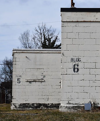

Former Bonebrake Theological Seminary
1601 W. First St., Dayton
Situated behind barbed wire fence in the middle of an unassuming Dayton neighborhood, many of the concrete buildings at this address (now private property) were part of the Manhattan Project! Several buildings housed equipment that was used to extract polonium and others were used for radiation research. The property was protected by armed guards 24 hours a day and its true purpose remained classified until the 1960s. Today, you can look, but not touch. The property is on the National Register of Historic Places.

The J.K. McIntire Company Building in Dayton. The top three floors were also part of the Manhattan Project, as well as a research facility.
The J.K. McIntire Company Building 601 E. Third St., Dayton
The top three floors of this six-story brick warehouse (near Fifth Third Field and 2nd Street Market) were rented by Monsanto in 1945. They housed one of the nation’s first large-scale radiation health safety programs, studied the biological effects of radiation and received, sorted and stored critical equipment and materials for the project.


LEFT: CD-78 Nike Missile launch site near Oxford, Ohio, while under construction in 1959. HERE: Later generation Nike missiles.
(Photos US Air Force)


Initiated in the 1940s, and operational through the early 1970s, Nike missile sites were America’s first nationwide, ground-based air defense system, built to stop Soviet nuclear bombers (and later nuclear weapons) from reaching major U.S. cities during the Cold War. More than 300 were built nationwide, often arranged in defensive rings around major cities, including Cincinnati and Cleveland. The public was often unaware of what they were or that they even existed. Their purpose was to detect incoming bombers/missiles, track them with radar, launch surface-to-air missiles, and destroy them before they reached cities or military targets, including Wright-Patterson Air Force Base. In the case of nuclear weapons, the goal was to destroy the missiles over a city, which was considered better than a direct hit.
In Ohio, there were at least 11 Nike missile sites in operation, each manned 24 hours a day, 7 days a week for more than a decade. Personnel described the work as “repetitive, highly procedural and quietly nerve-wracking.” Some missile sites were located in urban areas, while others were hidden in the farmland or near the Ohio River and Lake Erie.
Thankfully, they were never used. In fact, as soon as the Soviet Union developed Intercontinental Ballistic Missiles, the Nike sites became obsolete and were quickly decommissioned. Today, most sites have been demolished or paved over (several are community parks), with the exception of a few. At least one site is occasionally open to the public, including during Halloween time!


Located at 6529 Todd Rd. in Oxford, (less than two miles southwest of Hueston Woods State Park), Nike Missile Site CD-78 was operational between 1959 and 1971. It is currently owned by Miami University, serving a number of purposes, including as the home of the Area 13 Project, which is how the general public can gain access to the property.
The goal of the Area 13 Project is to restore the historical missile site so it can be opened for tours and made available to veterans and historians. To raise funds, it hosts several public tours each year, as well as haunted tours (and sometimes an actual haunted house) in the fall. You can learn more about the organization and its activities at area13project.com or by scheduling a tour by calling (513) 893-5585. Tours take visitors to rarely seen areas of the former missile site, all in a post-apocalyptic setting!
The site and its old silos and buildings are also visible from the road, making it a fun side trip when traveling to Hueston Woods!
Ironically, or not, there is a former Nike missile site located not far away at 1133 Fruit Ridge Rd…in Moscow, Ohio.


The longest fence line in Ohio surrounds this Army base in Ravenna, once home to a munitions factory during WWII, as seen in these historical photos from the National Archive.


During World War II, the Ravenna Arsenal in northeast Ohio was one of the most productive munitions factories in the United States. More than 14,000 employees worked around the clock loading, assembling, and packaging over 36 million bombs and artillery shells, which were stored in hundreds of concrete bunkers scattered across the site’s vast 22,000 acres (still visible on Google Earth). A dense rail network—tied into Ohio’s steel-producing heartland—allowed munitions to be shipped efficiently to ports and military bases for deployment overseas.
Beyond rail access and isolation from major population centers, the site was chosen because this part of Ohio is frequently overcast, providing natural concealment from aerial reconnaissance during the war.
After World War II, the mission at Ravenna shifted. The facility was used to demilitarize and dismantle surplus munitions, with some explosive materials repurposed for agricultural use (ammonia-based fertilizer) during Europe’s postwar recovery. In the early 1950s, the site took on an even more unusual role when NACA—the forerunner of NASA—conducted aircraft impact and structural tests here, sending planes crashing into the ground in the name of aviation research. This must have been an unforgettable spectacle for nearby residents!
Ammunition production and recycling continued at Ravenna through the Cold War, finally ending in the early 1990s. By the mid-1990s, the property was designated a Superfund cleanup site, contaminated by unexploded ordnance, explosive residues, and long-lasting industrial chemicals that still linger in parts of the soil and groundwater today. For years, large portions of the massive complex sat silent and off-limits.
Today, the site is known as Camp James A. Garfield, home to the Ohio Army National Guard’s Joint Training Center. Soldiers train here in realistic combat and live-fire scenarios, and it is not uncommon for nearby residents to hear distant booms echo across the landscape.
In recent years, the property has been considered a top finalist for a multi-billion dollar “East Coast Missile Defense System,” which (like Nike missile sites) would shoot down incoming enemy missiles. It’s also being used in cyber defense training, allowing soldiers to practice defending military communications and infrastructure from digital attacks.


Although almost entirely off-limits to the public, and surrounded by 33-miles of continuous fence line (the longest in Ohio!), there are actually three ways that civilians can access Ravenna Arsenal. First, the Ohio Department of Natural Resources holds an annual lottery to hunt the land. The massive enclosed wooded property is known to have an “unsustainable” deer population. Up to 260 permits are issued each year. Interestingly, one of the largest deer ever recorded in Ohio came from this site.
Second, the Portage (County) Foundation auctions off a private tour of the camp each year to raise money. The tour explores the WWII ammunition bunkers and visits training areas and other locations that are normally off-limits to the public. All you have to do is bid the highest at their annual auction.
Finally, every so often, the Newton Falls Preservation Foundation hosts a bus tour to the facility, usually in April. The public is always invited to join them.
Other than that, the only way to see this secretive base is to drive along the perimeter of the fence line, possibly while visiting the second oldest covered bridge still in use in Ohio in nearby Newton Falls!


Ohio ranks among the most important states in NASA’s mission, often considered fifth overall behind Florida, Texas, Alabama and California. Yet much of NASA’s future depends on work happening quietly right here in Cleveland and Sandusky.
NASA puts it plainly: “The Road to the Moon and Mars Goes Through Ohio.”
That road runs directly through NASA Glenn Research Center, a 350-acre campus next to Cleveland Hopkins International Airport. Here, thousands of engineers and scientists develop and test technologies designed to help astronauts reach and survive in deep space. Much of the work is public, but some remains classified.
About an hour west, the Neil Armstrong Test Facility covers 6,400 acres of what was once the Plum Brook Ordnance Works, a massive ammunition complex during World War II and the Cold War. Today the site houses some of the most advanced spacecraft testing facilities in the world, including the Space Power Facility—the largest vacuum chamber ever built—where satellites and spacecraft are subjected to the extreme conditions of space.
The Cleveland center has played a role in nearly every era of American spaceflight. Research here helped support the Mercury, Gemini and Apollo programs, ensuring astronauts could survive in orbit and beyond. During the Cold War, engineers conducted experimental aircraft testing and nuclear propulsion research—work that remains only partly understood outside the aerospace community.


TOP OF SECTION: At NASA Glenn Research Center’s Space Power Facility, engineers test spacecraft and space hardware under conditions that simulate the harsh environment of space.
HERE: A view of the Armstrong Test Facility from U.S. Route 250 near Sandusky and a sign near the road.
BELOW: An aerial view looking northeast towards Cleveland’s Hopkins Airport and a look inside. (Images by NASA)

Today, Glenn researchers are developing nuclear power systems for deep-space missions, advanced electric propulsion for Mars exploration, autonomous spacecraft technologies and cryogenic fuel systems. Much of this work will shape the next generation of human spaceflight, even if most Ohioans never see it firsthand.
Both facilities are largely closed to the public. Tours of Glenn have been suspended in recent years, and access to the Armstrong Test Facility is strictly controlled. From U.S. Route 250 near Sandusky, however, it is sometimes possible to glimpse the massive vacuum chamber dome rising above the surrounding farmland—a quiet reminder that some of the world’s most advanced space research is happening in places few people ever visit.
Until tours resume, the closest look most visitors can get is at the NASA exhibits inside the Great Lakes Science Center in Cleveland, where displays explain how Ohio’s research helps push human exploration deeper into space.
Speaking of space…


Likely the most secretive place in Ohio, Wright-Patterson Air Force Base has a long and guarded history—one that, for better or worse, often circles back to UFOs.
Even recently, the mystery hasn’t gone away. In December 2024, a series of unidentified "drone" incursions were reported over sensitive areas of the base and were never fully explained. A month later, similar objects were witnessed by more than 100 people in rural Mercer County. No clear answers have been offered.
For decades, the Miami Valley has been considered a UFO hot spot, a reputation many believe is tied to the presence of Wright-Patt itself. Sightings continue into the present day, reported by pilots, engineers and ordinary residents alike. The most famous connection dates back to Project Blue Book, the Air Force program (operated out of Wright-Patt) that investigated UFO sightings from 1952 to 1969. Because Wright-Patt analyzed foreign aircraft and advanced aerospace technology rumors have persisted that it may have examined something far more unusual.
Since the late 1940s, stories have circulated that debris from the Roswell UFO incident—and possibly other unidentified craft—was transported to the base and stored in the now-infamous Hangar 18. The Air Force has consistently denied that extraterrestrial materials were ever kept here, stating that Wright-Patt’s mission has always been the study of foreign technology, not alien artifacts. Still, the secrecy surrounding the base has kept the legend alive.
Today, Wright-Patterson remains one of the nation’s leading aerospace research centers. Behind the guarded gates, scientists and engineers develop advanced propulsion systems, directed-energy weapons and next-generation space technologies—work that ensures much of the base’s activity will remain classified for decades to come.
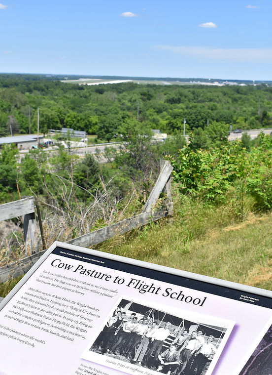
A view of the landing strip at Wright-Patt from Wright Brothers Memorial. At right: The base’s northern section in 2000 by the US Geological Survey.


Visitors can get a closer look at this hidden world at the nearby National Museum of the United States Air Force, where the public side of aviation history is on display. Just outside the base, Huffman Prairie Flying Field and the Wright Brothers Memorial mark the place where powered flight was perfected, with clear views toward the runways.
Wright-Patterson’s secrecy has helped fuel decades of speculation about what might be happening behind its fences. But the base has also left a more visible legacy. Investigations have found that chemicals released during decades of operations contaminated parts of the Mad River watershed with PFAS—so-called “Forever chemicals”—leading to one of Ohio’s most serious groundwater concerns.
Which brings us to the next stop.


The Ohio River—which provides drinking water for millions of people—is widely considered the most industrially polluted river in the United States. Chemical plants, steel mills, refineries and power stations legally discharge millions of pounds of pollutants into the water each year, while decades of earlier dumping left behind a long legacy of contamination. Fish consumption advisories cover large stretches of the river, warning that some species are unsafe to eat regularly. Other areas of the river are off limits to the public, mostly due to pollution hazards.
Before modern environmental regulations took hold in the 1970s, pollution levels were even worse. Many of the substances released into the river are known carcinogens or chemicals that accumulate in wildlife and the human body. Among the most troubling are PFAS—often called “Forever chemicals”—which do not naturally break down and are now found worldwide, from Antarctic snow to human bloodstreams.
No story illustrates the magnitude of this problem more clearly than what happened in the quiet river town of Little Hocking in southern Ohio.
Beginning in the 1950s, DuPont operated its Washington Works Teflon plant in Parkersburg, West Virginia, just across the river from Little Hocking. The facility used a chemical known as C8, a PFAS compound essential to the production of Teflon—the nonstick coating used in cookware as well as in waterproof fabrics, electrical insulation and industrial equipment.
For decades, waste containing C8 was released into the Ohio River and surrounding environment. Little Hocking’s public water system drew directly from the river, unknowingly exposing residents to the chemical for generations.

Coal-fired power plants and chemical factories line the Ohio River, a vital water source for millions that still carries the scars of decades of industrial pollution, including PFAS contamination in towns like Little Hocking.


By the early 2000s, testing revealed elevated C8 levels in the town’s drinking water. Blood tests showed that many residents carried concentrations several times higher than the national average. Long-term studies later linked exposure to kidney cancer, testicular cancer, thyroid disease and other serious illnesses.
The Little Hocking contamination became one of the nation’s most significant PFAS cases, leading to major lawsuits, medical monitoring programs and national attention on Forever chemicals and the health of the Ohio River.
Today, a drive along Ohio’s stretch of the river is a mix of emotions. Most of the time, the route passes through some of the most beautiful scenery in the state and quiet river towns like Little Hocking. Then suddenly the landscape shifts—smokestacks, tanks and industrial yards pressing close to the water’s edge, all reminders that the Ohio River remains both a vital resource and a working industrial corridor—two roles that have never comfortably coexisted.
For those seeking to witness these contrasts in person, the Ohio River probably reveals the state’s beauty and its scars more vividly than anywhere else.


Ohio is home to more than 4,000 abandoned mines, relics of the state’s 19th- and 20th-century iron and coal booms that left a lasting mark on the environment. Acid drainage from these mines now affects over 1,300 miles of streams, sometimes wiping out all aquatic life, according to the Ohio Department of Natural Resources. While most of these mines have been sealed and largely forgotten, one site refuses to be ignored—and it can still be visited.
Tucked into the hills of southeastern Ohio, the small village of New Straitsville sits atop one of the state’s strangest and longest-burning secrets: an underground coal fire that has smoldered since 1884. Started during a coal miner’s strike, the fire continues nearly 140 years later beneath portions of the village and into the surrounding Wayne National Forest. Occasionally, thin wisps of smoke rise from cracks in the forest floor, and the ground feels warm even on cool mornings.
One of the best places to potentially see this smoke—and even stand atop the actual “fire zone”—is the Upstream Rock Run Reclamation Site, a nature preserve that commemorates the New Straitsville Mine Fire, also known as the “World’s Greatest Mining Fire.” A historical marker explains that during the 1884 strike, at least six miners set fire to coal cars and pushed them into the mine to halt operations after wages were cut and strikebreakers were brought in. The plan backfired, igniting the coal seam underground.


Although a fire still burns beneath the ground, the scars of Ohio’s past are beginning to heal in some places, including here.
The top photo is a mural dedicated to the fire, found in New Straitsville.
According to the U.S. Forest Service, the burning seam in the early years caused the ground to collapse beneath buildings and roads. Mine gases seeped into schools and homes, forcing many residents to leave. Yet the fire also drew curiosity. Word spread that roses bloomed in winter and potatoes could be baked in the heated soil, attracting visitors eager to witness the phenomenon firsthand. The fire gained international attention, briefly turning New Straitsville into a renowned tourist destination. Even today, snow melts faster over affected areas, including the nature preserve.
A walk around the Upstream Rock Run Reclamation Site—and, to a lesser degree, the Fernald Preserve—offers a glimpse of nature’s slow reclamation. Vegetation has returned, wildlife has moved back into the habitat, and the site demonstrates how abandoned mine lands can recover—even while the coal seam below continues to smolder, or, in other places, uranium quietly lingers.

Visiting Ohio’s “top secret” and forbidden sites is definitely not a typical road trip. It’s a journey through the state’s hidden history, where progress and damage often exist side by side. From Fernald’s quiet wetlands masking a radioactive past, to Piketon’s massive industrial complex rising above contaminated ground, to the long-burning coal fire beneath New Straitsville, these places reveal a side of Ohio many people never see—or would rather not see.
What becomes clear along the way is that many of Ohio’s greatest achievements came with lasting consequences, some still unfolding decades later. Driving past missile silos, former weapons depots and restricted government facilities, it’s easy to see how much of the state’s history developed out of public view—and how deeply those decisions shaped the landscape, possibly for eons to come.
Seeing these places in person puts that history into perspective. The same trip can pass through beautiful forests, quaint small towns and peaceful nature preserves before arriving at fenced compounds and scarred ground. Few places reveal Ohio’s beauty and its scars so clearly in the same landscape.
In the end, these sites show that Ohio’s past is never very far away. It lingers in unexpected places—along quiet country roads and in landscapes that look ordinary at first glance—waiting to be noticed by those willing to look a little closer.
You may also enjoy...