


Read this article in its original magazine format HERE.
The rich history of western Ohio, and the murals that capture it so vividly, can be discovered on the back roads and in the small towns and villages of this majestic and timeless region.
Here, in places like Greenville, Piqua and Fort Recovery, murals, museums and monuments invite curious travelers to learn about events and people that changed the course of history, not just in Ohio, but on a global scale.
Driving along Ohio Route 49, for example, travelers will pass nearly a dozen historic sites where world-changing events occurred, such as the War of 1812, the Northwest Indian War, and the Treaty of Greenville, and where legends like Tecumseh, Annie Oakley and Johnny Appleseed walked and rose to fame.


Greenville is a very historical town, built where Fort Greene Ville was constructed in the 18th century and a place where legends such as Tecumseh, Annie Oakley and Johnny Appleseed walked and rose to fame. LEFT: A marker for the Treaty of Greenville. MIDDLE: A statue of Tecumseh at Shawnee Prairie Preserve in Greenville. RIGHT: A statue of Annie Oakley overlooking downtown Greenville.
Not far away, Ohio Route 66, known as the “Miami and Erie Canal Scenic Byway,” explores a different part of Ohio history, passing dozens of sites (and murals) related to the canal (built in 1825 and in use until 1913). This starts with a ride on the General Harrison canal boat at the Johnston Farm & Indian Agency in Piqua and spans all the way to Delphos with a visit to the Canal Museum—and so much more in between, from canal locks and boats to gravity defying aqueducts and historic bridges, many situated in picturesque towns like New Bremen, Minster and St. Marys.
Those interested in hiking through canal history can look into a 40-mile stretch of the Miami and Erie Canal Towpath Trail that runs from Fort Loramie to Delphos, largely through beautiful, wooded corridors, quiet farmland and quaint canal towns.
The arrival of the canal in western Ohio also led (eventually) to the creation of two of the region’s greatest recreational treasures—Grand Lake St. Marys (the largest lake in the world dug entirely by hand) and Lake Loramie, both of which were feeder reservoirs used to supply water to the canal system and that, today, are popular for boating, fishing and a host of recreational activities. Both lakes are located along Route 66 at the highest point along the canal system, hence the need for the reservoirs.


TOP ROW: The Miami & Erie Canal Scenic Byway passes through one of the most bucolic parts of Ohio, including passing through the small village of New Bremen, where a restored lock and other attractions can be enjoyed.
BOTTOM ROW: The museum at Johnston Farm & Indian Agency in Piqua and its canal boat, which takes visitors on an authentic ride along the Miami and Erie Canal. Plan your visit HERE.
The age of the canal also inadvertently led to this part of Ohio becoming the Land of Cross-Tipped Churches—a geographical area consisting of more than 60 historic churches and structures, 33 of which are listed on the National Register of Historic Places. The structures (located mostly south and southwest of Grand Lake) were built by German-Catholic immigrants and farmers in the 19th and early 20th centuries, many of whom also worked on/for the canal and whose descendents continue to live in the area today. The Gothic-Revival churches stand out like pinnacles in the vast fields in the area, including along Route 49 and U.S. 127. In fact, there are certain high points in the area where it is possible to see multiple steeples in one sweeping view, especially in the winter! These “spires to heaven” are impressive to see from far away, and even more so up-close!


This driving tour passes through a portion of the Land of Cross-Tipped Churches, which are centered around and to the south of Grand Lake St. Marys. (Take our Land of Cross-Tipped Churches Tour HERE)
LEFT: St. Augustine Church in Minster. MIDDLE: St. Michael Church in Fort Loramie. RIGHT: Although not an official part of the Land of Cross-Tipped Churches, St. John's Catholic Church in Delphos and others are just as beautiful to see.
BOTTOM: The Saint Charles Chapel in Carthagena.
Today, many towns in western Ohio honor their unique history and heritage with public works of art—specifically, with murals, but also with statues, architecture (both historic and new!) and other creative ways.
In Fort Recovery, for example, visitors can tour a replica fort, museum and battlefield (the site of both a crushing U.S. defeat in 1791 and a hard-won stand in 1794), and then walk around the historic downtown to view elaborate, building-sized murals that depict these historical events in amazing detail. Nearby is the Fort Recovery Monument (obelisk), which is the largest tomb of unknown soldiers in the world, honoring more than 1,000 souls. Other murals in the vicinity highlight the Harvest Jubilee Festival (held each June) and the town’s link to railroad and transportation history, which are two more common “themes” in western Ohio.
In St. Marys, a mural of the canal during its heyday is on display just a few feet away from the actual canal, as well as a replica canal boat, a lock, and several parks and historic buildings. Additional murals in the downtown show the canal being built by Irish and German immigrants and other historic scenes from St. Mary’s colorful past. All are within walking distance of each other.


Fort Recovery is one of the most significant places in early American history. Today, a replica fort, plus a museum, monument, several murals and historic markers allow visitors to get a full picture of two major events that occurred at this one place in western Ohio.
And the stories, artwork and small town charm don’t stop there.
With this in mind, the following 160 mile loop driving tour is a chance to explore western Ohio’s unique tapestry of history (and the murals and communities that capture it), and to experience the culture and recreation that has grown around it—all in one power-packed road trip. It’s a perfect fall drive/overnight trip, but can be enjoyed any time of year, including in the summer when the lakes provide a great place to cool off and when attractions like Johnston Farm and the Fort Recovery Museum are open for the season, and when local festivals are in full swing. (This is arguably one of the most festive regions in all of Ohio!)
Beyond history and murals, this tour visits beautiful parks and pastoral downtowns that beckon travelers to get out, explore, visit one-of-a-kind restaurants, boutiques and shops and simply to marvel at how unique and special each town is. Most of them retain their canal-era charm, which was often inspired by the Italianate architecture craze of the era—characterized by low overhanging roofs, bracketed cornices, tall, narrow, decorative windows, commercial blocks and lots of limestone and brickwork. Many of these same towns are also updating older buildings and properties in creative and innovative ways, often blending new designs with old ones to retain the historic charm. It’s a rare blend—and it makes each stop worth the journey.
Speaking of the journey… Starting on Ohio Route 66 in Piqua (where the byway begins), this tour follows the former path of the Miami and Erie Canal to the historic canal town of Delphos, a distance of about 60 miles. It then takes a short jog west on the Lincoln Highway to Van Wert and then south on Ohio Route 118 and U.S. 127 to Celina and the heart of the Land of Cross-Tipped Churches. Next, it follows a series of country roads to Fort Recovery and then Route 49 to Greenville. Finally, the tour returns to Piqua via U.S. 36 and a few other country roads, one of which leads to a final mural on the tour in downtown Bradford, possibly during the Bradford Pumpkin Show in October.


TOP ROW L-R: Downtown Celina. Antique shopping and line dancing in Delphos.
BOTTOM ROW: 19th century architecture in downtown Delphos (left) and St. Marys (right).
Whether in the spring, summer or fall, the following driving tour is a fun and worthwhile way to explore the fascinating history and culture of western Ohio, all without traveling very far from home…even though, with so many new things to see and do along the way, it might just feel like it!
So let’s begin. Points of Interest are highlighted in bold lettering and, when possible, are listed in the order they appear on the tour. The article spans two web pages; just press "Continue" once you reach the bottom of this page to finish the tour.
We’ll start in historic downtown Piqua. Enjoy and drive safely!


Although not mentioned in the introduction, music will be another common theme in the murals featured on this tour, including at the very start of the trip in downtown Piqua, where the new Mills Brothers Mural graces the Park National Bank building at 212 N. Main St. Fittingly, it is within view of Lock 9 Park, a new outdoor music and entertainment venue!
The Mills Brothers were a groundbreaking African American vocal group from Piqua, known for their smooth harmonies and ability to mimic instruments with their voices! (See them perform HERE.) Formed in the 1920s by four brothers—John Jr., Herbert, Harry, and Donald—they rose to fame with hits like “Tiger Rag” and “Paper Doll.” Their innovative style and wide appeal helped break racial barriers in the music industry, making them one of the most successful vocal groups of the 20th century with over 2,000 recordings and 50 million records sold. The mural, created by Michael Boudreault and Chris McDaniels from Artisan Rooms, was completed in 2024 and is a fine legacy to the group.


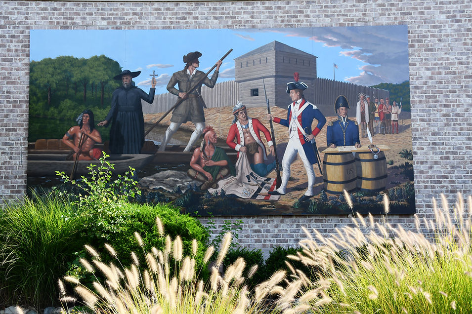
Just around the corner, and across from the Romanesque-style Fort Piqua Plaza, is the Piqua Founders Mural at 101 E. High St., which was partially damaged in a fire earlier this year. It is also sometimes called the “Native American History and Miami-Erie Canal Mural” as it captures these two key historical moments in Piqua’s history in one striking image.
For reference, the area that would one day become modern-day Piqua was originally home to the Shawnee and other Native peoples dating back thousands of years. In fact, the name “Piqua” itself comes from a Shawnee word. Later, the Miami‑Erie Canal brought commerce and growth to the region, helping establish Piqua as a key transportation and industrial hub. The downtown mural, completed in 2020 by artist Eric Henn, pays tribute to both eras.
Before exiting Piqua, Route 66 passes several of the town’s most colorful places—Fountain Park, Veteran’s Memorial Park (and William Pitsenbarger Memorial), Forest Hill Cemetery and Swift Run Lake, where a short walk on the River’s Edge Trail follows the Hydraulic Canal—arguably one of the most beautiful scenes in western Ohio, especially in the most colorful parts of spring and fall.


On the edge of town is the Johnston Farm & Indian Agency. During the regular season, a restored and working section of the Miami and Erie Canal and a museum dedicated to Native American history on the grounds helps set the tone for the rest of the tour, making it a perfect starting point for this tour.
The Johnston Farm & Indian Agency explores the life of Col. John Johnston, a prominent Indian agent, frontier diplomat, and farmer in early 19th-century Ohio who played a key role in U.S.–Native American relations and treaty negotiations. It also tells the story of Fort Pickawillany—a British/Miami Indian trading post established here in 1751 to challenge French influence in the region. A year later, French and Ottawa warriors attacked and destroyed Fort Pickawillany in a violent raid that included killing and cannibalizing one of the British-allied Miami chiefs—a key event leading up to the French and Indian War. Although nothing remains of Fort Pickawillany today, it is the first of numerous forts and fort locations highlighted on this trip, although this one is related to the French and Indian War while most of those on Route 49 were from the War of 1812 and Northwest Indian War.
Before entering Johnston Farm on Hardin Road, stop to view two Ohio historic markers, one that commemorates the “Battle of Pickawillany 1752” and another for the site’s namesake “John Johnston.” There’s also a stone marker that notes Pickawillany as the “headquarters of the Miami Tribes and First English Settlement” in Ohio and two other monuments. They can be visited even if Johnston Farm is closed.


For hikers interested in getting a closer look at this historic area, head north on Hardin Road (about 500 feet past the entrance to Johnston Farm) to the unmarked Buckeye Trailhead and take a scenic walk through the area where Pickawillany once stood and down to the old canal towpath and Great Miami River. The primitive trail then continues north to Lockington Locks and Dam, which, if you have time, is an excellent and quick (by car) side trip that fits in perfectly with this tour.


After Piqua, Route 66 moves through a quick procession of idyllic and historic canal towns, one after another, inviting travelers to stop often.
After passing through Houston and crossing State Route 47, the road reaches Newport, home to Keyhole Pizza and a stretch of the Miami & Erie Canal Trail. The St. Peter & Paul Catholic Church in Newport, although not part of the Land of Cross-Tipped Churches, has a beautiful stone design that is worth viewing up-close.
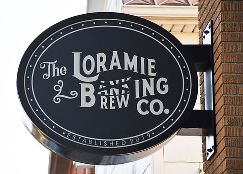
A little bit further up the road is Fort Loramie, which has a long and layered history.
The town began as a Shawnee trading post in 1769 by French trader Louis Lorimier. It was destroyed during a raid in 1782. After the Treaty of Greenville was signed in 1795 (ending the Northwest Indian War), the notorious General “Mad” Anthony Wayne built Fort Loramie as a supply depot, which was in service during the War of 1812.
In the 1830s, the village became a key stop along the Miami and Erie Canal, with nearby Loramie Creek dammed up to construct a feeder reservoir. The canal spurred growth until the arrival of the railroad, which eventually replaced canal commerce. Today, Fort Loramie is known for its historic roots, its German-Catholic heritage and festivals, Lake Loramie State Park and the annual Country Concert in the Hills.
There are also a number of attractions to enjoy in town, but no murals, yet.
On the southern edge of town is the Fort Loramie Trading Post (cowboy boots, work shoes, statues and other unique items, including Bigfoot below!), while the center of town contains several historical markers and displays that focus on the community’s canal history.
If it is Sunday between 1-4 p.m. (June through September), stop by the Wilderness Trail Museum at 37 N. Main St. Museum displays include Indian artifacts, mementos of the Miami-Erie Canal era and much more. The museum’s Genealogy Room is open from 9 a.m. to noon on Tuesdays.


Along with a visit to nearby Lake Loramie State Park (very beautiful in the fall!), take time to view the St. Michael Catholic Church (33 Elm St.)—a crown jewel of the Land of Cross-Tipped Churches, which you’ll now begin seeing more of on the tour.
For a bite to eat or a beverage, stop in at The Fort Loramie Brewing Company. Located at 17 N. Main St. in a historic little bank building, the pub offers a variety of different comfort foods, plus craft beers and great coffee drinks. Nearby, diners also enjoy the chicken dinners at Brucken’s Neighborhood Pub, 10 Elm St.


Just a short drive north of Fort Loramie is wonderful Minster, Ohio, home of the famous Minster Oktoberfest (first weekend in October), Wooden Shoe Inn (also known for famous chicken dinners) and the stunning duel steeples at St. Augustine Catholic Church, among other local treasures.
The next set of murals is also located in Minster—specifically on the exterior of the Minster Historical Society and Museum, 112 W. Fourth St.
Painted by Katelyn Puthoff, the three panels show a farming scene, Minster’s original log cabin church, and a scene from the historic downtown, each with a plaque explaining its meaning.


In order to tour the museum and learn more about the town and region, visit on Tuesdays from 10 a.m. to 2 p.m., or Sundays from 1-3 p.m. The museum is a popular place to research local genealogy as well.
A true canal town, many of the eclectic buildings in the historic district were built as hotels, taverns and warehouses. Most still retain their original charm, inviting travelers to get out for a closer look.


A stone’s throw north of Minster is the picture-perfect town of New Bremen—today the global headquarters of Crown Equipment and a magical place filled with history and small town charm.
On the south end of town are two new additions to the community—Caddy’s Golf Lounge & Craft Eatery where guests can play simulation golf and grab a bite to eat and The Pie Shell, a specialty bakery known for its Tiramisu and located at 468 S. Washington St.
To experience the best of New Bremen, park at Lock One Park in the heart of town and take a stroll through the community on foot, starting with Canal Lock 1. This beautifully restored lock is located next to a replica lock tender’s house (and statue) and Blackhoof St. Bridge, which is a very rare canal-era pedestrian bridge. Historic signage throughout the area tells the story of the canal in detail.


From here, take a short walk down Monroe Street to view the town’s amazing architecture (mostly Italianate, but also German-influenced) and to visit The Bicycle Museum of America or to grab a steak or seafood dinner at 17 West.
There are two notable churches (and steeples) in New Bremen, the St. Paul United Church of Christ, 119 N. Franklin St., and St. Peters Church at 303 N. Franklin St.
Before continuing north on Route 66, make one last stop in New Bremen at the Kuenning-Dicke Natural Area, where gravel hiking trails lead past several war memorials and monuments in a peaceful country setting. Also, make sure to sneak a peak at the American Legion Post 241 building (6458 Rt. 66) on the edge of town, known for its unusual dome shape!


The town with the most murals on this tour is St. Marys, and a majority of them are located along Spring Street—a place that has a ton of other interesting things to see and do, so give yourself plenty of time to explore.
The most impressive murals are located in Heritage Park (202 E. Spring St., pictured above). Painted by New Bremen artist Dan Keyes, the three large murals (titled “Girty’s Town,” “Canal Town” and “Boom Town”) represent different time periods (old and new) in St. Marys. The park also contains other artwork and displays that celebrate the town’s two sister cities: Awaji City, Japan and Lienen, Germany.
Not far from Heritage Park are Canal Lock 13 and the St. Marys Reservoir Mill, as well as access to the Miami Erie Canal Bike/Walk Path. Tucked away, behind the Mayor’s office at 106 E. Spring St., near the canal lock, is the Belle of St. Marys Mural, depicting a canal boat from yesteryear. And just beneath the old stone bridge on the walking path is an actual replica of the Belle of St. Marys Canal Boat, sitting in water and open for visitors to explore. In Memorial Park, next to the boat, are a beautiful bell tower, veteran’s memorial and Memorial Covered Bridge, among other attractions.


One of the most beautiful murals on this tour is the Arts Place Mural (207 E. Spring St.), created by Sarah and Alli Hess of Maria Stein. It depicts a gardener watering plants and a child painting, expressing the importance of creativity.
Finally, St. Marys has two murals based off of old postcards, one on public display and another located inside of a downtown business.
The Greetings from St. Marys Ohio Mural is on display behind 205 W. Spring St., near the intersection of Main Street. It was created by Linette’s Painting & Fine Art and is based on a tourism-themed postcard.
Not far from here, the Miami & Erie Trading Co. (209 W. Spring St.) has a mural on display that is based on a historic Victorian postcard. It was painted by Chris Ballweg. The shop, described as “a modern twist on the general store” is open 11 a.m. to 5 p.m. Wednesday-Friday and 10 a.m. to 3 p.m. Saturday.
There are also a number of other great places to shop, and a variety of restaurants and venues to try out, from the Friendly Tavern and Island Dress Shoppe to GR8 Vines Winery and the Grand Opera House Live, where you can take in comedy, music, theater and more!
Last but not least, Grand Lake St. Marys State Park is located just west of Route 66, offering camping, boating, fishing, and a little bit of hiking.


The stretch of Route 66 between St. Marys and Spencerville (my favorite part of this trip) contains some very interesting canal attractions, as well as a side trip to a very moving and impressive site dedicated to the War of 1812.
The first stop is Miami Erie Canal Lock 14, a historic site that can be reached by turning left on Lock 14 Rd. just north of St. Marys on Route 66. Located in a remote park (with a few residential homes nearby), visitors will soon learn that this area was once a town with a mill, homes and a church. However, when the mill went out of business, so did the town. The canal lock is a reconstruction of what was once a wooden lock.


Next up is Bloody Bridge, a location tied to a 19th-century legend that may or may not be true. According to the legend (and a historic marker at this roadside park), two canal workers—Bill Jones and Jack Billings—were rivals for the affection of a woman named Minnie. One day, after a heated argument along the Miami and Erie Canal, Jones allegedly killed Billings with an axe, dismembered him, and threw the pieces into the canal from the bridge at this location! The water ran red, and locals began calling it “Bloody Bridge.”


Less than a mile north of Bloody Bridge is a rare treat—the Six Mile Aqueduct, which is a water-filled bridge used by canal boats to cross over another body of water; in this instance, Six Mile Creek. It is one of the few surviving canal aqueducts in Ohio and has been fully restored. Historical signage and walking trails highlight this small, but worthwhile stop.
Next up is Deep Cut Historical Park. The “Deep Cut” was one of the most ambitious and difficult engineering feats of the Miami and Erie Canal. In order to avoid using locks in this high section between two watersheds, German and Irish immigrants dug (by hand) 52-feet deep through blue clay and limestone. The project took several years and was plagued by disease, accidents and hard working conditions in the “Black Swamp.” Today, park visitors can learn about the project through interpretative signage and a short set of walking trails.


A short (and highly recommended) side trip from Deep Cut Historical Park leads to the Fort Amanda Memorial Park where a 50-foot-tall obelisk erected in 1915 marks the location of a fort used to supply the U.S. Army during the War of 1812. The fort was built under the command of future U.S. President, General William Henry Harrison. A short but very scenic walking trail leads to the obelisk and contains signage that explains the history of the fort and war. There is also a historic cemetery that has 75 headstones of unknown soldiers from the War of 1812 and several memorials dedicated to them. The park is located along the Auglaize River at 22800 Ohio 198, less than 6 miles from the Deep Cut. It is a serene place.
On the way to Delphos, stop by 1699 Defiance Trail Rd. to view the location (with historic signage) of a Johnny Appleseed nursery location! Johnny Appleseed, born John Chapman, was an American pioneer nurseryman who traveled the frontier (including western Ohio) planting apple orchards and spreading a spiritual mission of simplicity, generosity, and harmony with nature. He is depicted in several murals on this tour.


The last canal town on this tour—and one of its most memorable stops—is Delphos. Founded in 1851 through the merging of four small towns, Delphos quickly grew into a bustling shipping hub thanks to its prime location on the Miami-Erie Canal. The canal not only moved goods but also brought waves of German and Irish immigrants, who helped shape the community’s culture and left behind some of the most extravagant architecture you’ll see on this journey.
One highlight is the façade of the Delphos Canal Commission Museum, a worthwhile stop with three floors of exhibits on the golden age of canal travel (open 9 a.m. to noon Thursdays and 1–3 p.m. Saturday and Sunday). Another is the legendary Pete’s Hongkong Mayflower Chinese Restaurant—famous as much for its historic design as for its menu. Its rare “stair tower,” a covered exterior staircase popular in the late 1800s, once served as a weather-protected fire escape. Similar features can still be spotted on the town squares in Greenville and Van Wert.
Delphos also boasts remarkable churches, including St. John the Evangelical Catholic Church. Although not part of the Land of the Cross-Tipped Churches, its soaring white-stone façade and clock-tower steeple make it an architectural treasure.
Art lovers will find plenty to admire here as well. The town is rich in murals, beginning with a folk-art “Welcome to Delphos” painting on the south end of town, near the Senior Center at 301 E. Suthoff St. The most impressive, however, is the massive “Early Days of the Miami-Erie Canal” mural on the exterior of the Delphos Herald at 405 N. Main St. Painted in 1995 by the late Oscar Velasquez, a celebrated regional muralist, it vividly captures the town’s canal-era roots. Velasquez also created the nearby “Firestone Mural” at 66 E. 5th St., depicting Delphos in the 1950s. Just steps away, you’ll find a soldier’s monument, a veteran’s park, and easy access to downtown shops and restaurants—including The Mill, a new eatery in a historic-style building that blends seamlessly with the community’s character. The Mill serves hearty fare like steaks, chicken, seafood, and pasta, open for lunch and dinner daily except Mondays.
Rounding out the mural scene are “The Lion of Judah” at 114 N. Main St. and four painted windows overlooking a parking lot at 330 N. Main St.
For those looking to extend their stay, the Victorian Guesthouse at 331 E. 3rd St. offers a charming and surprisingly affordable bed-and-breakfast experience, with rooms under $100 per night—a perfect place to rest before the next leg of your journey.

A six-mile detour north of Delphos on Ohio Route 190 north leads to the village and historic site of Fort Jennings.
The community traces its origins to the War of 1812, when the U.S. Army built a stockade here in 1812–1813 under the command of Colonel William Jennings. The fort protected supply lines and settlers along the Auglaize River from potential attacks during the conflict with British forces and their Native American allies. Strategically positioned between Fort Defiance and Fort Amanda, it served as both a defensive outpost and a staging point for troop movements into northwest Ohio. Today, Fort Jennings Park preserves this history with several monuments and wooden carvings, while additional signage can be found at the Fort Jennings Memorial Hall, 360 N. Water St.


