


From downtown Delphos, jump on the historic and nostalgic Lincoln Highway (the first transcontinental highway for automobiles) and drive about 13 miles west to Van Wert for the next set of murals. If the season is right, there are several quirky stops to enjoy in between, not to mention a number of vintage signs and buildings leftover from the highway’s heyday to view. The first stop is the Van-Del Drive-In, open through October, followed by the Haunted Middle Point School in the small town of Middle Point. The 1885 former school building has long been rumored by locals to be haunted by its former students and it is available for ghost hunts. Finally, set up camp at Huggie Bear Campground—a massive campground with lots of fun amenities, especially in the summer.
On the outskirts of Van Wert, look for the Welcome to Van Wert barn painting.


Unlike the canal- and colonial-era towns on this tour, Van Wert rose to prominence in the age of the locomotive—and even more so with the birth of the automobile. Multiple rail lines made it a vital shipping hub for grain, livestock, and manufactured goods. But when the Lincoln Highway cut through in 1913, the town truly accelerated. Service stations, restaurants, and hotels sprang up to welcome travelers, with the grand Hotel Marsh—still standing today as an entertainment venue—at the center of it all.
By the 1930s, Van Wert had blossomed into the “Peony Capital of the World.” Vast fields of flowers thrived in the fertile soil, and the Peony Festival, launched in 1932, drew crowds of more than 100,000. The tradition lives on each year during the first full weekend of June.
The town also boasts four murals, historic architecture, and a lively downtown of shops, restaurants, and attractions. The largest and oldest mural, tucked behind the Garden of Senses and R Place Stone Grill at 139 E. Main St., portrays the majestic Van Wert County Courthouse—a striking example of Second Empire architecture—alongside scenes from historic Main Street. Just around the corner, the “If Not Now Then When” mural graces 134 Main St., while at 124 E. Main St. the “Mayor Eugene Bagley Alley Mural” celebrates local life with images of wind turbines, musicians, farmers, landmarks, and, of course, peonies. Another musical mural, this one a psychedelic portrait of a guitarist, peeks from the side of The Well, a health food restaurant at 109 S. Washington St.


Beyond the murals, Van Wert offers plenty to explore. The Brumback Library—the first countywide public library in America—looks like a castle straight out of Europe. Antique shops, boutiques, and specialty stores line Main Street. And next to the courthouse, the Armed Forces Album preserves the faces and stories of local veterans in a chapel-like building.
For a final stop, swing by Laurie’s Naturescapes at 12368 Ohio 118—a garden and décor destination that makes a perfect pause before continuing on to Rockford.


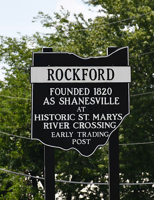

Heading back south on Route 118, the road first rolls through Ohio City, proudly known as the birthplace of the “First Successful Automobile” in 1891. This curious invention—a gas-powered buggy built by John William Lambert—put the tiny village on the map long before Detroit claimed the automobile spotlight. A few miles later, travelers arrive in the welcoming town of Rockford, where one of the greatest “mural treasures” on this tour awaits.
The Rockford Bicentennial Mural, painted by Dan Keyes in 2020, commemorates 200 years of local history. Spanning the south wall of the Rockford Fire Department at 201 S. Main St., the vibrant artwork brings to life the many figures who once crossed the nearby St. Marys River. Among them are Celeron de Bienville, a French explorer; Fr. Joseph Bonnecamp, the Jesuit cartographer who mapped this part of Ohio; members of the Delaware and Miami tribes, the region’s first inhabitants; General Anthony Wayne, who secured the Northwest Territory for the young United States; and Anthony and Mary Shane, early settlers considered a “founding father and mother” of the town. You’ll also spot Rev. Isaac McCoy, missionary to Native tribes; future president William Henry Harrison; Major Stephen Long, an explorer and engineer; Captain James Riley, famed for his survival memoir; biographer Benjamin Drake; and the ever-familiar figure of Johnny Appleseed.
A sign beside the mural identifies each figure and explains their role in shaping the region. Taken together, the scene is not just public art but a sweeping panorama of frontier history—telling how cultures, explorers, and pioneers converged along the riverbanks where Rockford now stands.
After soaking in the mural, you may be ready for a bite. Local favorites include Ole’ 1820, serving pizza, subs, and sandwiches, and Second Crossing Brewing Co., where craft beer and small bites pair perfectly with the town’s warm, small-town atmosphere.

To reach Celina from Rockford, take U.S. 33 east, then U.S. 127 south—but consider a quick detour to two unique attractions along the way.
The first is the MVP Dairy Learning Center (7124 U.S. 33), where visitors can tour a modern dairy farm. Hours are noon to 5 p.m. Tuesday–Friday from Labor Day through Memorial Day, and 10 a.m. to 5 p.m. Tuesday–Friday plus 10 a.m. to 3 p.m. Saturdays during the summer season. A small admission fee applies (details at dairylearningcenter.com).
Just across the street is Prairiewood Primitives (7271 Bogart Rd.), a rural shop specializing in primitive country home décor, handcrafted wood and upholstered furniture, and seasonal items. Hours are 11 a.m. to 5 p.m. Thursday and Friday, 10 a.m. to 3 p.m. Saturday, and in November–December, 1 to 4 p.m. on Sundays.


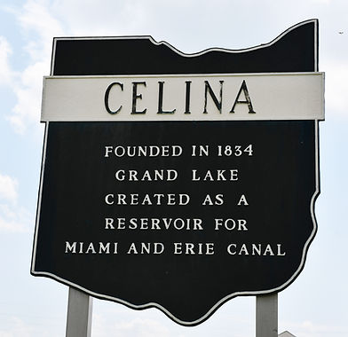


Just three years after Celina was officially platted in 1834, a crew of mostly hard-drinking canal workers arrived to dig a massive reservoir beside the young town. Their backbreaking labor created what we now know as Grand Lake St. Marys, intended to supply the canal in nearby St. Marys. Some of those men eventually settled here, but Celina didn’t truly flourish until the 1890s, when oil was discovered beneath the lake.
Remarkably, Grand Lake St. Marys became the site of the world’s first official offshore oil drilling operation, with wooden derricks rising straight out of the water. The boom was brief—by the early 1900s production had dried up—but it left an indelible mark on the region’s history. After the Great Flood of 1913 brought an end to the canal era, the lake was reborn as a public park and, in 1949, designated one of Ohio’s first state parks. Today, it thrives as a vibrant destination for boating, fishing, and summer getaways.
Along the western shore, highlights include the Grand Lake St. Marys Lighthouse—built in 1923 and modeled after England’s famous Eddystone Lighthouse—the lively Boardwalk Village and Boardwalk Grill, and family-friendly Mercelina Park, where the town’s lake spirit comes alive.


Downtown Celina embraces “Lake Life” through a collection of colorful murals. The most recognizable is the “Greetings from Celina” mural at 219 S. Main St. by Wrenway Creations LLC, which frames a Great Blue Heron against a lake sunset. Nearby, The Bay Restaurant (117 Lake Shore Dr.) is graced by a bright sunflower mural, while another mural—children flying a kite near the lighthouse—can be found inside the entrance of Walmart at 1950 Havemann Rd.
Celina also offers architectural gems, including the Immaculate Conception Catholic Church, a Romanesque Revival treasure built in 1903 and a rare standout within the Land of the Cross-Tipped Churches.
Before leaving town, be sure to stop at the Bear Hollow Sasquatch Carving at the Mercer County Fairgrounds (4874 Mud Pike Rd.), created to mark the 2024 Total Solar Eclipse. And for those willing to detour to the lake’s southwest shore, a final surprise awaits: the Behem’s (Grimm Memorial) Lighthouse at 8521 Howard Dr., standing watch beside Duckfoot’s Bar & Grill, a favorite local hangout known for pizza, live music, and unbeatable lake views.


Our next major stop is Fort Recovery, but the road there winds through two classic small towns—Coldwater and St. Henry—via Ohio Routes 219, 118, and 119.
In Coldwater, the vibrant Coldwater Mural is a must-see. It’s located on the exterior of Coldwater Elementary School (310 N. 2nd St., facing Route 118) and depicts local historical figures and citizens standing next to Coldwater Creek. It also pays tribute to the Land of the Cross-Tipped Churches.
While in town, try a pastry at Home Bakery (109 W. Main St.)—a local favorite for more than 80 years, or enjoy some delicious BBQ at Southside Restaurant (490 S. 2nd St.). On the outskirts of town, the Vineyard at Evergreen Farm (4240 Siegrist-Jutte Rd.) offers a spacious tasting room, live entertainment, and 22 different wines to sample.
Just a short drive away in St. Henry, don’t miss the St. Henry Catholic Church—soaring over 200 feet, it holds the distinction of being the tallest of the Land of the Cross-Tipped Churches.


Fort Recovery stands on one of the most significant battlefields in early American history. In 1791, U.S. forces under General Arthur St. Clair suffered a catastrophic defeat here at the hands of a powerful Native American confederation led by Miami Chief Little Turtle and Shawnee leader Blue Jacket. Known as St. Clair’s Defeat, it remains the worst loss ever suffered by the U.S. Army in a Native American battle. Just two years later, General Anthony Wayne returned to the same ground, constructing Fort Recovery as both a strategic stronghold and a symbolic act of resilience. In 1794, thousands of Native warriors, supported by British allies, laid siege to the fort—but the garrison held. That victory gave Wayne the momentum to triumph at the Battle of Fallen Timbers, which in turn led to the Treaty of Greenville and opened much of Ohio to settlement.
Today, a visit to Fort Recovery feels like stepping directly into the pages of early American history. At the center of the village is the Fort Recovery State Museum, which tells the story of both St. Clair’s Defeat and the 1794 Siege with exhibits, artifacts, and interactive displays. The museum is open Wednesday–Sunday, 11 a.m. to 4 p.m., with admission being just $5. Outside, a reconstructed section of the fort—complete with blockhouses, palisades, and cannon—brings the 18th century to life, while a 1.5-mile loop walking tour with 15 wayside exhibits explores key historic sites. Nearby stands the striking Fort Recovery Monument, built in 1913, which honors the U.S. soldiers who fell here. Beneath its base lie the remains of many who died in both battles.


The village is also home to some of the most striking murals on this tour. Painted largely by artist Dan Keyes (four in total), they depict scenes from the battles at Krenning Park (117 Wayne St.), as well as its farming and transportation history, including the Harvest Jubilee Festival Mural (101 E. Butler St.) and the Postage-Stamp Mural (130 Wayne St.). Artist Angie Clark contributed the colorful “Welcome to Fort Recovery” mural at 110 E. Boundary St. on the exterior of the IGA.
Beyond its battlefield heritage, Fort Recovery offers a charming small-town atmosphere with numerous historic markers, shops, and dining spots. Favorites include The Tin Cupboard, Simple Touch, and the Sunshine Boutique—perfect for rounding out a visit steeped in both history and local flavor.


Ohio Route 49, formerly a well-traveled “Indian Trail,” has witnessed a remarkable amount of history, though many sites are now on private property and easy to miss. Fortunately, several markers are still visible from the road.
The first stop is the Historic Anthony Wayne Parkway Roadside Park at 1501 Mercer Darke County Line Rd., a public site marking the headwaters of the Wabash River with informative historical signage. Further along the route, three other markers sit on private property with very limited parking.
The Camp Mississinawa Marker in New Weston, installed in 1937, commemorates the temporary military encampment established by General St. Clair’s army in 1791 during the Northwest Indian War. Troops camped here next to the Stillwater River, positioning artillery at the center of two parallel lines before marching eight miles to the pivotal Battle of Fort Recovery.
Less than four miles later, the Camp Stillwater Marker in Rossburg marks where Major General “Mad” Anthony Wayne’s army set up camp on the night of July 28, 1794, after advancing 12 miles from Fort Greene Ville during their campaign in the Maumee Valley. The 600-yard-square camp, roughly 70 acres, featured protective breastworks of felled trees, and the following day the troops resumed their march along a worn Native American trail, eventually reaching present-day Fort Recovery.
Finally, the Camp Sulphur Springs Marker commemorates another temporary encampment used during the Northwest Indian War in 1791.


Greenville, one of the most historic and entertaining towns on this tour, is the birthplace of legendary sharpshooter Annie Oakley and home to a number of impressive murals. The town is most famous as the site of the Treaty of Greenville, which ended the Northwest Indian War and opened the Ohio frontier to settlement. Treaty of Greenville State Park (503 Douglas Dr.) features a reconstruction of Fort Greene Ville—the largest stockade fort in North America at the time—and a stone monument marking the treaty boundary. Nearby attractions include the Peacock House and the Swinging Bridge.
Throughout downtown, numerous historic signs and markers tell the stories of the treaty, Tecumseh, Annie Oakley, and other local figures and events, including at Annie Oakley Park (Broadway and St. Rt. 571) and Shawnee Prairie Preserve (4267 Ohio 502). Today, Greenville is also known for its vibrant downtown shopping and dining district, with antique stores, specialty shops, boutiques, and restaurants such as The Montage Café and the famous gum-walled Maid-Rite Sandwiches.


Traveling from Fort Recovery, Route 49 ends at Greenville Union Cemetery, a place that features numerous historic gravestones and monuments. For a broader view of the town’s history, the Garst Museum (205 N. Broadway) offers over 1,000 artifacts related to the Treaty of Greenville and other local history, including exhibits on Annie Oakley, born in 1860 near Greenville. The Darke County Visitor’s Bureau’s Annie Oakley Trail guides visitors to sites connected to her life, from her birthplace to her final resting place.
Greenville is also rich in murals and public art. The newest, the Downtown Greenville Mural (501 S. Broadway), is a digitized design based on a 1981 collage by Greenville native Jeffrey Feltman, depicting the city’s historic homes and buildings. Feltman, a 1977 Greenville High School graduate, went on to serve in the U.S. Foreign Service and as United Nations Under-Secretary-General for Political Affairs. The Don Mong Mural (200 S. Broadway), painted by its namesake, portrays a watercolor scene of Treaty of Greenville State Park near the fountain square. Nearby is the Corynna Strawser Mural on the exterior of Beanz Buttercream (180 E. 3rd St.), honoring the owner’s daughter, who passed away in 2013, and featuring her drawing alongside commemorative text.
The final murals are near the new Yolo Urban Park (100 Martin St.), including the Annie Oakley Mural and the Greetings from Greenville Mural on the south side of 622 S. Broadway, completing the town’s rich tapestry of history, art, and culture.


To conclude the tour, follow U.S. 36 east toward Piqua. About five miles outside of town is Historic Bears Mill (6450 Arcanum Bears Mill Rd.), which is always worth a stop. From U.S. 36, take Ohio Route 721 north to Bradford to see the final mural of the trip, the Bradford Mural, celebrating the community’s rich train history. While in town, visit the Bradford Railroad Museum (200 N. Miami Ave.) and nearby parks to explore more of the area’s railroad heritage. Don’t miss a hearty meal at The Train Stop, known for its famous biscuits and gravy.
On the way back to Piqua, consider stopping at Twenty One Barrels Hard Cider & Wine, Maple Ridge Reserve, and Stillwater Prairie Reserve to round out the day with local flavors and scenic views.
And that’s a wrap! We hope you enjoyed this tour, though it only scratches the surface of the history and hidden treasures along the back roads and in the small towns of western Ohio. Consider this journey just the beginning of uncovering the region’s rich and fascinating past.

